Geolocate

Midland topographic map

Click on the map to display elevation.

About this map

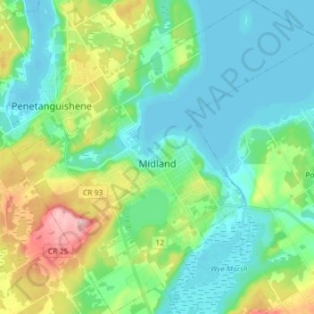
Name: Midland topographic map, elevation, terrain.

Location: Midland, Simcoe County, Central Ontario, Ontario, Canada (44.70149 -79.95052 44.80297 -79.81112)

Average elevation: 686 ft

Minimum elevation: 574 ft

Maximum elevation: 991 ft

Other topographic maps

Click on a map to view its topography, its elevation and its terrain.

Mad River

Canada > Ontario > Simcoe County > Springwater

Average elevation: 600 ft

Anten Mills

Canada > Ontario > Simcoe County > Springwater

Average elevation: 719 ft

Brechin

Canada > Ontario > Simcoe County > Ramara Township

Average elevation: 751 ft

Collingwood

Canada > Ontario > Simcoe County > Collingwood

Average elevation: 617 ft

Dunedin

Canada > Ontario > Simcoe County > Clearview

Average elevation: 1,322 ft

Gear up for your next adventure:

🪑Ultralight Camp Chairs - Portable seating for resting after a long day of mapping
🖼️Topo Map Wall Art - Decorative topographic prints of famous peaks and regions
🏔️Mountain Trail Maps - High‑detail maps for popular peaks
❄️Traction Cleats - Prevent slips on icy trails during winter hikes
🪶Compact Camp Shovel - Folding shovel for campsite tasks

As an Amazon Associate, this site earns from qualifying purchases at no extra cost to you.