
Make a donation
Gear up for your next adventure:
As an Amazon Associate, this site earns from qualifying purchases at no extra cost to you.
Viehhofen topographic map
Click on the map to display elevation.
Make a donation
Gear up for your next adventure:
As an Amazon Associate, this site earns from qualifying purchases at no extra cost to you.
Viehhofen
The town lies at an elevation of 856 m above sea level in the middle of Glemmtal Valley, through which flows the River Saalach. The valley's main town is our western neighbor, Saalbach-Hinterglemm. To the east, at the entrance to the valley, you will find the village of Maishofen.
Make a donation
Gear up for your next adventure:
As an Amazon Associate, this site earns from qualifying purchases at no extra cost to you.
About this map
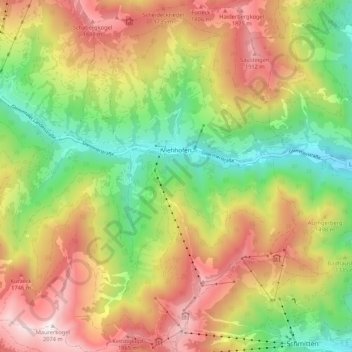
Name: Viehhofen topographic map, elevation, terrain.
Location: Viehhofen, Bezirk Zell am See, Salzburg, 5752, Austria (47.32486 12.67016 47.39696 12.77287)
Average elevation: 4,514 ft
Minimum elevation: 2,559 ft
Maximum elevation: 6,775 ft
Make a donation
Gear up for your next adventure:
As an Amazon Associate, this site earns from qualifying purchases at no extra cost to you.
Other topographic maps
Click on a map to view its topography, its elevation and its terrain.
Hinterglemm
Austria > Salzburg > Bezirk Zell am See > Saalbach-Hinterglemm
Average elevation: 4,567 ft
Strohwolln
Austria > Salzburg > Bezirk Zell am See > Sankt Martin bei Lofer
Average elevation: 3,143 ft
Großvenediger
Austria > Salzburg > Bezirk Zell am See > Neukirchen am Großvenediger
Average elevation: 10,430 ft
Make a donation
Gear up for your next adventure:
As an Amazon Associate, this site earns from qualifying purchases at no extra cost to you.
Großes Wiesbachhorn
Austria > Salzburg > Bezirk Zell am See > Fusch an der Großglocknerstraße
Average elevation: 9,446 ft
Make a donation
Gear up for your next adventure:
As an Amazon Associate, this site earns from qualifying purchases at no extra cost to you.
Sankt Martin bei Lofer
Austria > Salzburg > Bezirk Zell am See > Gemeinde Sankt Martin bei Lofer
Average elevation: 2,995 ft
Make a donation
Gear up for your next adventure:
As an Amazon Associate, this site earns from qualifying purchases at no extra cost to you.
Schmalenbergham
Austria > Salzburg > Bezirk Zell am See > Saalfelden am Steinernen Meer > Thor
Average elevation: 2,572 ft
Make a donation
Gear up for your next adventure:
As an Amazon Associate, this site earns from qualifying purchases at no extra cost to you.
Königsleiten
Austria > Salzburg > Bezirk Zell am See > Gemeinde Wald im Pinzgau
Average elevation: 5,587 ft
Make a donation
Gear up for your next adventure:
As an Amazon Associate, this site earns from qualifying purchases at no extra cost to you.
Hohlwegen
Austria > Salzburg > Bezirk Zell am See > Saalfelden am Steinernen Meer
Average elevation: 3,629 ft
Make a donation
Gear up for your next adventure:
As an Amazon Associate, this site earns from qualifying purchases at no extra cost to you.
Make a donation
Gear up for your next adventure:
As an Amazon Associate, this site earns from qualifying purchases at no extra cost to you.
Obersulzbachkees
Austria > Salzburg > Bezirk Zell am See > Marktgemeinde Neukirchen am Großvenediger
Average elevation: 9,045 ft
Wald im Pinzgau
Austria > Salzburg > Bezirk Zell am See > Gemeinde Wald im Pinzgau
Average elevation: 3,816 ft