
Make a donation
Gear up for your next adventure:
As an Amazon Associate, this site earns from qualifying purchases at no extra cost to you.
Round Lake Park topographic map
Click on the map to display elevation.
Make a donation
Gear up for your next adventure:
As an Amazon Associate, this site earns from qualifying purchases at no extra cost to you.
About this map
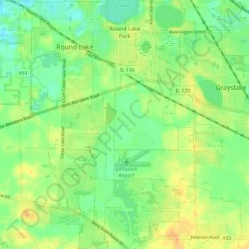
Name: Round Lake Park topographic map, elevation, terrain.
Location: Round Lake Park, Lake County, Illinois, United States (42.30330 -88.08747 42.36477 -88.05305)
Average elevation: 794 ft
Minimum elevation: 745 ft
Maximum elevation: 850 ft
Lake County trails, hiking, mountain biking, running and outdoor activities
Make a donation
Gear up for your next adventure:
As an Amazon Associate, this site earns from qualifying purchases at no extra cost to you.
Other topographic maps
Click on a map to view its topography, its elevation and its terrain.
Sand Lake
United States > Illinois > Lake County > Lindenhurst > Venetian Village
Average elevation: 787 ft
Make a donation
Gear up for your next adventure:
As an Amazon Associate, this site earns from qualifying purchases at no extra cost to you.
Waukegan
United States > Illinois > Lake County > Waukegan
Waukegan is located at 42°22′13″N 87°52′16″W / 42.37028°N 87.87111°W / 42.37028; -87.87111 (42.3703140, −87.8711404). Waukegan is on the shore of Lake Michigan, about 11 miles (18 km) south of the border with Wisconsin and 41 miles (66 km) north of downtown Chicago, at an elevation of…
Average elevation: 656 ft
Make a donation
Gear up for your next adventure:
As an Amazon Associate, this site earns from qualifying purchases at no extra cost to you.
Bull Creek Terrace
United States > Illinois > Lake County > Beach Park > Bull Creek Terrace
Average elevation: 653 ft
Make a donation
Gear up for your next adventure:
As an Amazon Associate, this site earns from qualifying purchases at no extra cost to you.
Skokie Manor
United States > Illinois > Lake County > Lake Forest > Skokie Manor
Average elevation: 682 ft
Founders Park, Beach Park Il
United States > Illinois > Lake County > Beach Park > Beach Park Country Estates
Average elevation: 640 ft
Make a donation
Gear up for your next adventure:
As an Amazon Associate, this site earns from qualifying purchases at no extra cost to you.