
Dahme/Mark topographic map
Interactive map
Click on the map to display elevation.
About this map
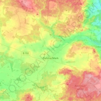
Name: Dahme/Mark topographic map, elevation, terrain.
Location: Dahme/Mark, Teltow-Fläming, Brandebourg, 15936, Allemagne (51.79073 13.27156 51.97715 13.56801)
Average elevation: 344 ft
Minimum elevation: 187 ft
Maximum elevation: 528 ft
Other topographic maps
Click on a map to view its topography, its elevation and its terrain.
Neuer Canal vom Schneide Graben zum Notten Fluss
Allemagne > Brandebourg > Teltow-Fläming > Saalow
Neuer Canal vom Schneide Graben zum Notten Fluss, Zossen, Saalow, Am Mellensee, Teltow-Fläming, Brandebourg, 15838, Allemagne
Average elevation: 128 ft
Jüterbog
Allemagne > Brandebourg > Teltow-Fläming
Jüterbog, Teltow-Fläming, Brandebourg, 14913, Allemagne
Average elevation: 253 ft