Geolocate

Cartignano topographic map

Click on the map to display elevation.

About this map

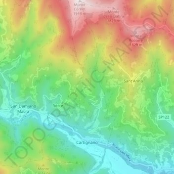
Name: Cartignano topographic map, elevation, terrain.

Location: Cartignano, Cuneo, Piedmont, 12025, Italy (44.46723 7.26686 44.52430 7.30132)

Average elevation: 3,642 ft

Minimum elevation: 2,067 ft

Maximum elevation: 6,342 ft

Other topographic maps

Click on a map to view its topography, its elevation and its terrain.

Montescotto

Italy > Piedmont > Cuneo > Barge

Average elevation: 2,110 ft

Bertolini

Italy > Piedmont > Cuneo > Crissolo

Average elevation: 5,531 ft

Monastero

Italy > Piedmont > Cuneo > Mondovì

Average elevation: 1,470 ft

Pievetta

Italy > Piedmont > Cuneo

Average elevation: 2,411 ft

Pianche

Italy > Piedmont > Cuneo

Average elevation: 4,908 ft

San Bernolfo

Italy > Piedmont > Cuneo > Vinadio

Average elevation: 6,680 ft

Gear up for your next adventure:

🌡️Handheld Weather Meters - Measure wind, temp, and pressure for safe mountain travel
🦶Carbon Trekking Poles - Reduce knee impact on steep descents with ultra-light poles
🗺️NatGeo Topo Maps - High-quality waterproof printed topographic maps of US Parks
🚁Photography Drones - Capture stunning aerial views of landforms and topography
💧Water Purification System - Clean water on the trail with reliable purifiers

As an Amazon Associate, this site earns from qualifying purchases at no extra cost to you.