Geolocate

Culpeper topographic map

Click on the map to display elevation.

About this map

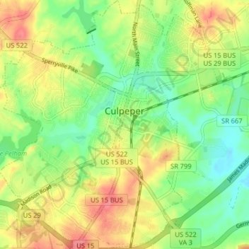
Name: Culpeper topographic map, elevation, terrain.

Location: Culpeper, Culpeper County, Virginia, 22701, United States (38.44113 -78.03194 38.49575 -77.95625)

Average elevation: 430 ft

Minimum elevation: 312 ft

Maximum elevation: 758 ft

Culpeper County trails, hiking, mountain biking, running and outdoor activities

Other topographic maps

Click on a map to view its topography, its elevation and its terrain.

Rapidan

United States > Virginia > Culpeper County

Average elevation: 344 ft

Cedar Mountain

United States > Virginia > Culpeper County

Average elevation: 489 ft

Rixeyville

United States > Virginia > Culpeper County

Average elevation: 390 ft

Cedar Mountain

United States > Virginia > Culpeper County

Average elevation: 489 ft

Rapidan

United States > Virginia > Culpeper County

Average elevation: 344 ft

Gear up for your next adventure:

🦶Carbon Trekking Poles - Reduce knee impact on steep descents with ultra-light poles
🧣Merino Neck Gaiters - Multi-functional headwear for wind and sun protection
📱Heavy-Duty Phone Cases - Drop-proof and waterproof protection for outdoor navigation
🦺Reflective Outdoor Gear - Safety gear for low‑light conditions
📶Satellite Messenger - Communication device off‑grid

As an Amazon Associate, this site earns from qualifying purchases at no extra cost to you.