
Pine Forest Range Wilderness Area topographic map
Interactive map
Click on the map to display elevation.
About this map
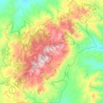
Name: Pine Forest Range Wilderness Area topographic map, elevation, terrain.
Average elevation: 6,834 ft
Minimum elevation: 4,948 ft
Maximum elevation: 9,367 ft
Other topographic maps
Click on a map to view its topography, its elevation and its terrain.
Sonoma Valley
United States > Nevada > Humboldt County
Sonoma Valley, Humboldt County, Nevada, United States
Average elevation: 6,732 ft
Paradise Valley
United States > Nevada > Humboldt County
Paradise Valley, Humboldt County, Nevada, 89426, United States
Average elevation: 4,551 ft
Golconda
United States > Nevada > Humboldt County
Golconda, Humboldt County, Nevada, 89414, United States
Average elevation: 4,436 ft
Winnemucca
United States > Nevada > Humboldt County
Winnemucca, Humboldt County, Nevada, 89445, United States
Average elevation: 4,478 ft
Winnemucca
United States > Nevada > Humboldt County > Winnemucca > Winnemucca
Winnemucca, Humboldt County, Nevada, 89445, United States
Average elevation: 4,603 ft