
Make a donation
Gear up for your next adventure:
As an Amazon Associate, this site earns from qualifying purchases at no extra cost to you.
Golconda topographic map
Click on the map to display elevation.
Make a donation
Gear up for your next adventure:
As an Amazon Associate, this site earns from qualifying purchases at no extra cost to you.
About this map
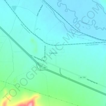
Name: Golconda topographic map, elevation, terrain.
Location: Golconda, Humboldt County, Nevada, 89414, United States (40.93262 -117.50573 40.97262 -117.46573)
Average elevation: 4,436 ft
Minimum elevation: 4,341 ft
Maximum elevation: 4,895 ft
Humboldt County trails, hiking, mountain biking, running and outdoor activities
Make a donation
Gear up for your next adventure:
As an Amazon Associate, this site earns from qualifying purchases at no extra cost to you.
Other topographic maps
Click on a map to view its topography, its elevation and its terrain.
Pine Forest Range Wilderness Area
United States > Nevada > Humboldt County
Average elevation: 6,834 ft