Geolocate

Cardiff topographic map

Click on the map to display elevation.

About this map

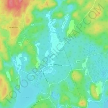
Name: Cardiff topographic map, elevation, terrain.

Location: Cardiff, Highlands East, Haliburton County, Central Ontario, Ontario, K0L 1M0, Canada (44.97574 -78.03462 45.01574 -77.99462)

Average elevation: 1,201 ft

Minimum elevation: 1,106 ft

Maximum elevation: 1,421 ft

Other topographic maps

Click on a map to view its topography, its elevation and its terrain.

Esson Lake

Canada > Ontario > Haliburton County > Highlands East

Average elevation: 1,381 ft

Cope Lake

Canada > Ontario > Haliburton County > Highlands East

Average elevation: 1,486 ft

Colborne Lake

Canada > Ontario > Haliburton County > Highlands East

Average elevation: 1,388 ft

Monck Lake

Canada > Ontario > Haliburton County > Highlands East

Average elevation: 1,368 ft

Paudash Lake

Canada > Ontario > Haliburton County > Highlands East > Cardiff

Average elevation: 1,207 ft

Lochlin Lake

Canada > Ontario > Haliburton County > Highlands East

Average elevation: 1,198 ft

Tory Creek

Canada > Ontario > Haliburton County > Highlands East

Average elevation: 1,289 ft

Colbourne Creek

Canada > Ontario > Haliburton County > Highlands East

Average elevation: 1,355 ft

Gear up for your next adventure:

🧭Outdoor Navigation Book - Learn advanced navigation skills
🗺️Topographic Maps - Detailed topo maps for hiking, exploring and outdoor navigation
🪓Survival Multi‑Tool - Versatile tool for camp and trail tasks
🛶Inflatable Kayak - Portable kayak for rivers, lakes, and expeditions
🔦Powerful Headlamps - Ultra-bright hands-free lighting for night navigation

As an Amazon Associate, this site earns from qualifying purchases at no extra cost to you.