
Make a donation
Gear up for your next adventure:
As an Amazon Associate, this site earns from qualifying purchases at no extra cost to you.
Mount English topographic map
Click on the map to display elevation.
Make a donation
Gear up for your next adventure:
As an Amazon Associate, this site earns from qualifying purchases at no extra cost to you.
About this map
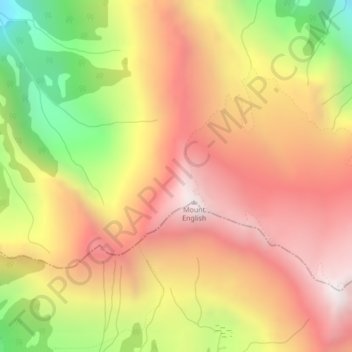
Name: Mount English topographic map, elevation, terrain.
Average elevation: 7,116 ft
Minimum elevation: 4,826 ft
Maximum elevation: 8,773 ft
Make a donation
Gear up for your next adventure:
As an Amazon Associate, this site earns from qualifying purchases at no extra cost to you.
Other topographic maps
Click on a map to view its topography, its elevation and its terrain.
Mara Lake
Canada > British Columbia > Columbia-Shuswap Regional District > Area E (Eagle River Valley) > Swansea Point
The lake is 35.3 kilometres (21.9 mi) long. The surface area is about 1,943 hectares (4,800 acres) and elevation is 338 metres (1,109 ft) above sea level. The mean and maximum depth is 18 metres (59 ft).
Average elevation: 2,710 ft