
Make a donation
Gear up for your next adventure:
As an Amazon Associate, this site earns from qualifying purchases at no extra cost to you.
Sankt Lambrecht topographic map
Click on the map to display elevation.
Make a donation
Gear up for your next adventure:
As an Amazon Associate, this site earns from qualifying purchases at no extra cost to you.
About this map
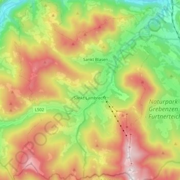
Name: Sankt Lambrecht topographic map, elevation, terrain.
Location: Sankt Lambrecht, Bezirk Murau, Stiermarken, 8813, Oostenrijk (47.02574 14.23635 47.12713 14.35944)
Average elevation: 4,104 ft
Minimum elevation: 2,451 ft
Maximum elevation: 6,191 ft
Make a donation
Gear up for your next adventure:
As an Amazon Associate, this site earns from qualifying purchases at no extra cost to you.
Other topographic maps
Click on a map to view its topography, its elevation and its terrain.
Sankt Lorenzen ob Murau
Oostenrijk > Stiermarken > Bezirk Murau > Sankt Georgen am Kreischberg
Average elevation: 3,563 ft
Diemersdorf
Oostenrijk > Stiermarken > Bezirk Murau > Neumarkt in der Steiermark
Average elevation: 3,238 ft
Make a donation
Gear up for your next adventure:
As an Amazon Associate, this site earns from qualifying purchases at no extra cost to you.
Sankt Georgen ob Murau
Oostenrijk > Stiermarken > Bezirk Murau > Sankt Georgen am Kreischberg
Average elevation: 3,625 ft
Sankt Lorenzen ob Murau
Oostenrijk > Stiermarken > Bezirk Murau > Sankt Georgen am Kreischberg
Average elevation: 3,563 ft
Make a donation
Gear up for your next adventure:
As an Amazon Associate, this site earns from qualifying purchases at no extra cost to you.