Geolocate

Sealy topographic map

Click on the map to display elevation.

About this map

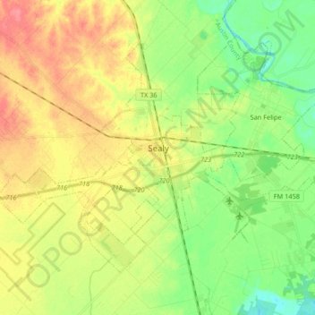
Name: Sealy topographic map, elevation, terrain.

Location: Sealy, Austin County, Texas, 77474, United States (29.72258 -96.24044 29.82635 -96.07605)

Average elevation: 177 ft

Minimum elevation: 85 ft

Maximum elevation: 289 ft

Austin County trails, hiking, mountain biking, running and outdoor activities

Other topographic maps

Click on a map to view its topography, its elevation and its terrain.

Kenney

United States > Texas > Austin County

Average elevation: 335 ft

Cat Spring

United States > Texas > Austin County

Average elevation: 295 ft

Alligator Hole

United States > Texas > Austin County

Average elevation: 105 ft

New Wehdem

United States > Texas > Austin County

Average elevation: 354 ft

Frydek

United States > Texas > Austin County

Average elevation: 151 ft

Burleigh

United States > Texas > Austin County

Average elevation: 171 ft

Gear up for your next adventure:

🚁Photography Drones - Capture stunning aerial views of landforms and topography
🔭Stargazing Telescopes - Perfect for camping in low-light pollution areas shown on maps
🛡️Insect Repellent - Protection against bugs during outdoor activities
🪶Fire Starter Kit - Reliable fire starter for survival and camping
🧯Portable Fire Pit - Compact fire pit for camping spots

As an Amazon Associate, this site earns from qualifying purchases at no extra cost to you.