Geolocate

New Ulm topographic map

Click on the map to display elevation.

About this map

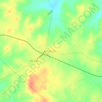
Name: New Ulm topographic map, elevation, terrain.

Location: New Ulm, Austin County, Texas, 78950, United States (29.87095 -96.50801 29.91095 -96.46801)

Average elevation: 387 ft

Minimum elevation: 302 ft

Maximum elevation: 463 ft

Austin County trails, hiking, mountain biking, running and outdoor activities

Other topographic maps

Click on a map to view its topography, its elevation and its terrain.

Bellville

United States > Texas > Austin County

Average elevation: 236 ft

Industry

United States > Texas > Austin County

Average elevation: 302 ft

San Felipe

United States > Texas > Austin County

Average elevation: 148 ft

Wallis

United States > Texas > Austin County

Average elevation: 131 ft

Gear up for your next adventure:

Backpacking Tents - Weight-optimized shelters for multi-day topographic surveys
🛡️Bear Spray Outdoor - Protection in bear country hikes
🔭Compact Binoculars - HD vision for scouting terrain and identifying distant landmarks
🩹Survival Bandages - High‑quality bandages for emergencies
🧷Carabiner Set - Durable clips for gear attachment

As an Amazon Associate, this site earns from qualifying purchases at no extra cost to you.