
Make a donation
Gear up for your next adventure:
As an Amazon Associate, this site earns from qualifying purchases at no extra cost to you.
Mont Alto topographic map
Click on the map to display elevation.
Make a donation
Gear up for your next adventure:
As an Amazon Associate, this site earns from qualifying purchases at no extra cost to you.
About this map
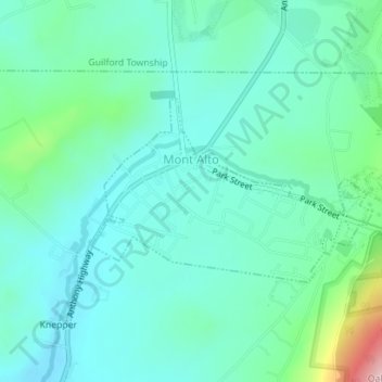
Name: Mont Alto topographic map, elevation, terrain.
Average elevation: 922 ft
Minimum elevation: 768 ft
Maximum elevation: 1,509 ft
Franklin County trails, hiking, mountain biking, running and outdoor activities
Make a donation
Gear up for your next adventure:
As an Amazon Associate, this site earns from qualifying purchases at no extra cost to you.
Other topographic maps
Click on a map to view its topography, its elevation and its terrain.
Church Hill
United States > Pennsylvania > Franklin County > Peters Township
Average elevation: 551 ft
Zullinger
United States > Pennsylvania > Franklin County > Washington Township
Average elevation: 709 ft
Williamson
United States > Pennsylvania > Franklin County > St. Thomas Township
Average elevation: 545 ft
Make a donation
Gear up for your next adventure:
As an Amazon Associate, this site earns from qualifying purchases at no extra cost to you.
Welsh Run
United States > Pennsylvania > Franklin County > Montgomery Township
Average elevation: 528 ft
Vanilla
United States > Pennsylvania > Franklin County > Montgomery Township
Average elevation: 515 ft
Make a donation
Gear up for your next adventure:
As an Amazon Associate, this site earns from qualifying purchases at no extra cost to you.
Upper Strasburg
United States > Pennsylvania > Franklin County > Letterkenny Township
Average elevation: 863 ft
Tomstown
United States > Pennsylvania > Franklin County > Quincy Township > Quincy
Average elevation: 866 ft
Stoufferstown
United States > Pennsylvania > Franklin County > Guilford Township
Average elevation: 682 ft
Make a donation
Gear up for your next adventure:
As an Amazon Associate, this site earns from qualifying purchases at no extra cost to you.
South Mountain
United States > Pennsylvania > Franklin County > Quincy Township
Average elevation: 1,637 ft
Shimpstown
United States > Pennsylvania > Franklin County > Montgomery Township
Average elevation: 571 ft
Make a donation
Gear up for your next adventure:
As an Amazon Associate, this site earns from qualifying purchases at no extra cost to you.
Shady Grove
United States > Pennsylvania > Franklin County > Antrim Township
Average elevation: 755 ft
Richmond Furnace
United States > Pennsylvania > Franklin County > Metal Township
Average elevation: 1,115 ft
Pleasant Hall
United States > Pennsylvania > Franklin County > Letterkenny Township
Average elevation: 682 ft
Make a donation
Gear up for your next adventure:
As an Amazon Associate, this site earns from qualifying purchases at no extra cost to you.
Old Forge
United States > Pennsylvania > Franklin County > Quincy Township
Average elevation: 1,273 ft
New Franklin
United States > Pennsylvania > Franklin County > Guilford Township
Average elevation: 758 ft
Monterey
United States > Pennsylvania > Franklin County > Washington Township
Average elevation: 1,322 ft
Mowersville
United States > Pennsylvania > Franklin County > Lurgan Township
Average elevation: 614 ft
Make a donation
Gear up for your next adventure:
As an Amazon Associate, this site earns from qualifying purchases at no extra cost to you.
Mason and Dixon
United States > Pennsylvania > Franklin County > Antrim Township
Average elevation: 584 ft
Mainsville
United States > Pennsylvania > Franklin County > Southampton Township
Average elevation: 804 ft
Make a donation
Gear up for your next adventure:
As an Amazon Associate, this site earns from qualifying purchases at no extra cost to you.
Kasiesville
United States > Pennsylvania > Franklin County > Montgomery Township
Average elevation: 686 ft
Make a donation
Gear up for your next adventure:
As an Amazon Associate, this site earns from qualifying purchases at no extra cost to you.
Greenwood
United States > Pennsylvania > Franklin County > Greene Township
Average elevation: 1,001 ft
Fannettsburg
United States > Pennsylvania > Franklin County > Metal Township
Average elevation: 955 ft
Make a donation
Gear up for your next adventure:
As an Amazon Associate, this site earns from qualifying purchases at no extra cost to you.
Doylesburg
United States > Pennsylvania > Franklin County > Fannett Township
Average elevation: 1,148 ft
Make a donation
Gear up for your next adventure:
As an Amazon Associate, this site earns from qualifying purchases at no extra cost to you.
Claylick
United States > Pennsylvania > Franklin County > Montgomery Township
Average elevation: 591 ft
Cheesetown
United States > Pennsylvania > Franklin County > Hamilton Township
Average elevation: 669 ft
Charlestown
United States > Pennsylvania > Franklin County > Peters Township
Average elevation: 876 ft
Make a donation
Gear up for your next adventure:
As an Amazon Associate, this site earns from qualifying purchases at no extra cost to you.
Fort Loudon
United States > Pennsylvania > Franklin County > Peters Township
Average elevation: 804 ft
Pen Mar
United States > Pennsylvania > Franklin County > Washington Township
Average elevation: 1,198 ft
Blue Ridge Summit
United States > Pennsylvania > Franklin County > Washington Township
Average elevation: 1,312 ft
Make a donation
Gear up for your next adventure:
As an Amazon Associate, this site earns from qualifying purchases at no extra cost to you.
Saint Thomas
United States > Pennsylvania > Franklin County > St. Thomas Township
Average elevation: 633 ft
Cowans Gap
United States > Pennsylvania > Franklin County > Metal Township > Cowans Village
Average elevation: 1,319 ft
Pond Bank
United States > Pennsylvania > Franklin County > Guilford Township
Average elevation: 1,001 ft
Make a donation
Gear up for your next adventure:
As an Amazon Associate, this site earns from qualifying purchases at no extra cost to you.
Caledonia State Park
United States > Pennsylvania > Franklin County > Greene Township > Caledonia Park
Average elevation: 1,204 ft