
Temple topographic map
Click on the map to display elevation.
Temple
Temple is a census-designated place in Muhlenberg Township, Berks County, Pennsylvania, United States at an elevation of 361 feet (110 m). The community was named for a local inn called Solomon's Temple. Temple was an independent borough until it was disincorporated on January 1, 1999. The ZIP code is 19560. As of the 2020 census the population was 2,073 residents.
About this map
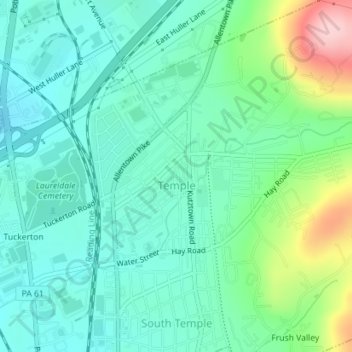
Name: Temple topographic map, elevation, terrain.
Average elevation: 413 ft
Minimum elevation: 249 ft
Maximum elevation: 899 ft
Berks County trails, hiking, mountain biking, running and outdoor activities
Other topographic maps
Click on a map to view its topography, its elevation and its terrain.
Riverview Park
United States > Pennsylvania > Berks County > Muhlenberg Township
Average elevation: 312 ft
Muhlenberg Park
United States > Pennsylvania > Berks County > Muhlenberg Township
Average elevation: 308 ft
Hyde Park
United States > Pennsylvania > Berks County > Muhlenberg Township > Muhlenberg Park
Average elevation: 351 ft