
Make a donation
Gear up for your next adventure:
As an Amazon Associate, this site earns from qualifying purchases at no extra cost to you.
Riverview Park topographic map
Click on the map to display elevation.
Make a donation
Gear up for your next adventure:
As an Amazon Associate, this site earns from qualifying purchases at no extra cost to you.
About this map
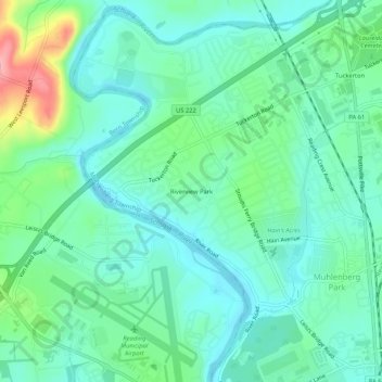
Name: Riverview Park topographic map, elevation, terrain.
Average elevation: 312 ft
Minimum elevation: 213 ft
Maximum elevation: 610 ft
Berks County trails, hiking, mountain biking, running and outdoor activities
Make a donation
Gear up for your next adventure:
As an Amazon Associate, this site earns from qualifying purchases at no extra cost to you.
Other topographic maps
Click on a map to view its topography, its elevation and its terrain.
Temple
United States > Pennsylvania > Berks County > Muhlenberg Township
Temple is a census-designated place in Muhlenberg Township, Berks County, Pennsylvania, United States at an elevation of 361 feet (110 m). The community was named for a local inn called Solomon's Temple. Temple was an independent borough until it was disincorporated on January 1, 1999. The ZIP code is 19560.…
Average elevation: 413 ft
South Temple
United States > Pennsylvania > Berks County > Muhlenberg Township
Average elevation: 390 ft