Pansol topographic map
Interactive map
Click on the map to display elevation.
About this map
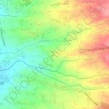
Name: Pansol topographic map, elevation, terrain.
Location: Pansol, Taal, Batangas, Calabarzon, 4208, Philippines (13.86023 120.93046 13.86856 120.94485)
Average elevation: 226 ft
Minimum elevation: 43 ft
Maximum elevation: 417 ft
Other topographic maps
Click on a map to view its topography, its elevation and its terrain.
Carasuche
Philippines > Batangas > Taal
Carasuche, Taal, Batangas, Calabarzon, 4208, Philippines
Average elevation: 305 ft
Bolbok
Philippines > Batangas > Taal
Bolbok, Taal, Batangas, Calabarzon, 4208, Philippines
Average elevation: 384 ft
Cawit
Philippines > Batangas > Taal > Cawit
Cawit, Taal, Batangas, Calabarzon, 4208, Philippines
Average elevation: 128 ft
Poblacion 13
Philippines > Batangas > Taal > Poblacion 13
Poblacion 13, Taal, Batangas, Calabarzon, 4208, Philippines
Average elevation: 125 ft