
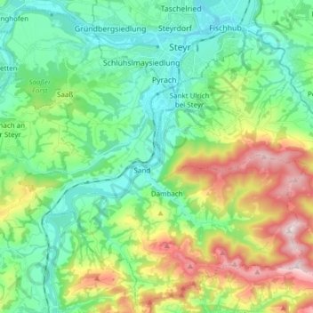
Garsten topographic map
Interactive map
Click on the map to display elevation.
About this map
Name: Garsten topographic map, elevation, terrain.
Location: Garsten, Bezirk Steyr-Land, 4451, Österreich (47.95513 14.32900 48.05165 14.48076)
Average elevation: 1,463 ft
Minimum elevation: 919 ft
Maximum elevation: 2,723 ft
Garsten liegt auf 298 m Höhe im Traunviertel am Rande der Eisenstadt Steyr. Die Ausdehnung der Marktgemeinde beträgt 11,4 km von Nord nach Süd und 10,7 km von West nach Ost. Ein Anteil von 39 % der Gemeindefläche ist bewaldet, 51,4 % sind landwirtschaftlich genutzt.
Other topographic maps
Click on a map to view its topography, its elevation and its terrain.
Goldberg
Österreich > Bezirk Steyr-Land > Schiedlberg
Goldberg, Schiedlberg, Bezirk Steyr-Land, 4521, Österreich
Average elevation: 1,220 ft
Pechgraben
Österreich > Bezirk Steyr-Land > Großraming
Pechgraben, Großraming, Bezirk Steyr-Land, 4463, Österreich
Average elevation: 1,975 ft
Maria Neustift
Österreich > Bezirk Steyr-Land
Maria Neustift, Bezirk Steyr-Land, 4443, Österreich
Average elevation: 2,080 ft
Steyr
Österreich > Bezirk Steyr-Land > Aschach an der Steyr
Steyr, Aschach an der Steyr, Bezirk Steyr-Land, 4421, Österreich
Average elevation: 1,322 ft
Gaflenz
Österreich > Bezirk Steyr-Land
Gaflenz, Bezirk Steyr-Land, 3334, Österreich
Average elevation: 2,211 ft