
Make a donation
Gear up for your next adventure:
As an Amazon Associate, this site earns from qualifying purchases at no extra cost to you.
Palmer Township topographic map
Click on the map to display elevation.
Make a donation
Gear up for your next adventure:
As an Amazon Associate, this site earns from qualifying purchases at no extra cost to you.
About this map
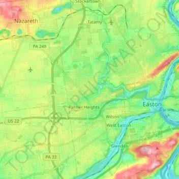
Name: Palmer Township topographic map, elevation, terrain.
Average elevation: 384 ft
Minimum elevation: 148 ft
Maximum elevation: 804 ft
Northampton County trails, hiking, mountain biking, running and outdoor activities
Make a donation
Gear up for your next adventure:
As an Amazon Associate, this site earns from qualifying purchases at no extra cost to you.
Other topographic maps
Click on a map to view its topography, its elevation and its terrain.
Illick's Mill Road Gateway
United States > Pennsylvania > Northampton County > Bethlehem
Average elevation: 344 ft
Make a donation
Gear up for your next adventure:
As an Amazon Associate, this site earns from qualifying purchases at no extra cost to you.
Weaversville
United States > Pennsylvania > Northampton County > East Allen Township
Average elevation: 423 ft
Kreidersville
United States > Pennsylvania > Northampton County > Allen Township
Average elevation: 495 ft
Moorestown
United States > Pennsylvania > Northampton County > Moore Township
Average elevation: 719 ft
Portlamd Waterfront Park
United States > Pennsylvania > Northampton County > Portland
Average elevation: 387 ft
Make a donation
Gear up for your next adventure:
As an Amazon Associate, this site earns from qualifying purchases at no extra cost to you.
Danielsville
United States > Pennsylvania > Northampton County > Lehigh Township
Average elevation: 833 ft
Martins Creek
United States > Pennsylvania > Northampton County > Lower Mount Bethel Township
Average elevation: 417 ft
West Bangor
United States > Pennsylvania > Northampton County > Washington Township
Average elevation: 1,017 ft
Mount Bethel
United States > Pennsylvania > Northampton County > Upper Mount Bethel Township
Average elevation: 512 ft
Make a donation
Gear up for your next adventure:
As an Amazon Associate, this site earns from qualifying purchases at no extra cost to you.
Mount Bethel
United States > Pennsylvania > Northampton County > Upper Mount Bethel Township
Average elevation: 512 ft
Brodhead
United States > Pennsylvania > Northampton County > Bethlehem Township
Average elevation: 377 ft
Make a donation
Gear up for your next adventure:
As an Amazon Associate, this site earns from qualifying purchases at no extra cost to you.
Northwood Heights
United States > Pennsylvania > Northampton County > Palmer Township > Palmer Heights
Average elevation: 361 ft