Geolocate

Nanming topographic map

Click on the map to display elevation.

About this map

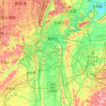
Name: Nanming topographic map, elevation, terrain.

Location: Nanming, Guiyang, Guizhou, 550012, China (26.44952 106.65604 26.63213 106.91629)

Average elevation: 3,848 ft

Minimum elevation: 3,255 ft

Maximum elevation: 4,764 ft

Other topographic maps

Click on a map to view its topography, its elevation and its terrain.

中排村榨哨组

China > Guizhou > Longli > 中排村

Average elevation: 4,980 ft

Tianping

China > Guizhou > Yuping Dong Autonomous County

Average elevation: 1,946 ft

Daxing

China > Guizhou > Songtao Miao Autonomous County > Daxing

Average elevation: 2,182 ft

Shandong

China > Guizhou > Shibing > Shandong

Average elevation: 3,281 ft

Renhuai

China > Guizhou > Renhuai

Average elevation: 3,337 ft

Xiangshui

China > Guizhou > Dafang

Average elevation: 4,675 ft

Gear up for your next adventure:

🛰️Handheld GPS Units - Professional satellite navigators for precise backcountry mapping
🔭Telescopic Hiking Pole - Adjustable pole for hiking stability
📱Solar Portable Charger - Solar power bank for charging devices off‑grid
🏥Hiking First Aid Kits - Comprehensive medical kits for remote trail injuries
🧢Outdoor Hiking Hat - Sun protection hat for outdoor explorers

As an Amazon Associate, this site earns from qualifying purchases at no extra cost to you.