
Vallejo topographic map
Click on the map to display elevation.
About this map
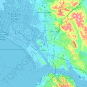
Name: Vallejo topographic map, elevation, terrain.
Location: Vallejo, Solano County, California, United States (38.05938 -122.38755 38.17350 -122.16615)
Average elevation: 148 ft
Minimum elevation: -16 ft
Maximum elevation: 1,106 ft
Solano County trails, hiking, mountain biking, running and outdoor activities
Other topographic maps
Click on a map to view its topography, its elevation and its terrain.