Geolocate

Lansing topographic map

Click on the map to display elevation.

Lansing

Lansing is a popular destination among retirees and tourists from Florida, as well as those from the lower elevations of the Carolinas and Georgia.

Wikipedia (CC-BY-SA 3.0)

About this map

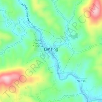
Name: Lansing topographic map, elevation, terrain.

Location: Lansing, Ashe County, North Carolina, United States (36.49284 -81.51856 36.50679 -81.50342)

Average elevation: 2,884 ft

Minimum elevation: 2,631 ft

Maximum elevation: 3,422 ft

Ashe County trails, hiking, mountain biking, running and outdoor activities

Other topographic maps

Click on a map to view its topography, its elevation and its terrain.

Ashland

United States > North Carolina > Ashe County

Average elevation: 3,219 ft

Crumpler

United States > North Carolina > Ashe County

Average elevation: 2,749 ft

Crumpler

United States > North Carolina > Ashe County

Average elevation: 2,749 ft

Orion

United States > North Carolina > Ashe County

Average elevation: 2,887 ft

Glendale Springs

United States > North Carolina > Ashe County

Average elevation: 2,923 ft

Apple Grove

United States > North Carolina > Ashe County

Average elevation: 3,284 ft

Dresden

United States > North Carolina > Ashe County

Average elevation: 3,087 ft

Warrensville

United States > North Carolina > Ashe County

Average elevation: 3,054 ft

Fleetwood

United States > North Carolina > Ashe County

Average elevation: 3,071 ft

Glendale Springs

United States > North Carolina > Ashe County

Average elevation: 2,923 ft

Todd

United States > North Carolina > Ashe County

Average elevation: 3,304 ft

Glendale Springs

United States > North Carolina > Ashe County

Average elevation: 2,923 ft

Warrensville

United States > North Carolina > Ashe County

Average elevation: 3,054 ft

Creston

United States > North Carolina > Ashe County

Average elevation: 3,228 ft

Todd

United States > North Carolina > Ashe County

Average elevation: 3,304 ft

Toliver

United States > North Carolina > Ashe County

Average elevation: 3,681 ft

Bina

United States > North Carolina > Ashe County

Average elevation: 2,933 ft

Ore Knob

United States > North Carolina > Ashe County

Average elevation: 3,035 ft

Mount Jefferson

United States > North Carolina > Ashe County

Average elevation: 3,537 ft

Creston

United States > North Carolina > Ashe County

Average elevation: 3,228 ft

Sutherland

United States > North Carolina > Ashe County

Average elevation: 3,291 ft

Gear up for your next adventure:

🏫Relief Map Kits - Hands-on tools for teaching landforms and elevation
🌡️Handheld Weather Meters - Measure wind, temp, and pressure for safe mountain travel
🛡️Insect Repellent - Protection against bugs during outdoor activities
🔌Solar Panel Charger - Charge gear sustainably outdoors
🧣Merino Neck Gaiters - Multi-functional headwear for wind and sun protection

As an Amazon Associate, this site earns from qualifying purchases at no extra cost to you.