
Warrensville topographic map
Click on the map to display elevation.
About this map
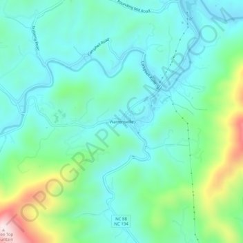
Name: Warrensville topographic map, elevation, terrain.
Average elevation: 3,054 ft
Minimum elevation: 2,631 ft
Maximum elevation: 4,439 ft
Ashe County trails, hiking, mountain biking, running and outdoor activities
Other topographic maps
Click on a map to view its topography, its elevation and its terrain.
West Jefferson
United States > North Carolina > Ashe County
West Jefferson is a popular destination among tourists and retirees from Florida, as well as those from the lower elevations of the Carolinas and Georgia.
Average elevation: 3,287 ft
Lansing
United States > North Carolina > Ashe County
Lansing is a popular destination among retirees and tourists from Florida, as well as those from the lower elevations of the Carolinas and Georgia.
Average elevation: 2,884 ft
Jefferson
United States > North Carolina > Ashe County
Due to its high elevation, Jefferson has an oceanic or subtropical highland climate, (Köppen Cfb), with the coldst month of January averaging slightly above freezing, while summers are much milder than most of the southeast, with July averaging below 70 degrees fahrenheit.
Average elevation: 3,212 ft
West Jefferson
United States > North Carolina > Ashe County
West Jefferson is a popular destination among tourists and retirees from Florida, as well as those from the lower elevations of the Carolinas and Georgia.
Average elevation: 3,287 ft