Geolocate

Colton topographic map

Click on the map to display elevation.

About this map

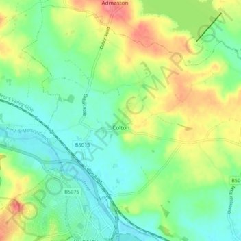
Name: Colton topographic map, elevation, terrain.

Location: Colton, Lichfield, Staffordshire, England, United Kingdom (52.76014 -1.95814 52.80779 -1.87579)

Average elevation: 295 ft

Minimum elevation: 217 ft

Maximum elevation: 430 ft

Other topographic maps

Click on a map to view its topography, its elevation and its terrain.

Watford Gap

United Kingdom > England > Staffordshire > Lichfield

Average elevation: 430 ft

Hademore

United Kingdom > England > Staffordshire > Lichfield > Whittington

Average elevation: 220 ft

Upper Longdon

United Kingdom > England > Staffordshire > Lichfield

Average elevation: 436 ft

Fradley

United Kingdom > England > Staffordshire > Lichfield

Average elevation: 194 ft

Hill Ridware

United Kingdom > England > Staffordshire > Lichfield

Average elevation: 253 ft

Little Aston

United Kingdom > England > Staffordshire > Lichfield

Average elevation: 466 ft

Edingale

United Kingdom > England > Staffordshire > Lichfield

Average elevation: 207 ft

Beacon Park

United Kingdom > England > Staffordshire > Lichfield

Average elevation: 305 ft

Lynn

United Kingdom > England > Staffordshire > Lichfield > Stonnall

Average elevation: 420 ft

Gentleshaw

United Kingdom > England > Staffordshire > Lichfield > Longdon

Average elevation: 571 ft

Armitage

United Kingdom > England > Staffordshire > Lichfield

Average elevation: 262 ft

Hopwas

United Kingdom > England > Staffordshire > Lichfield

Average elevation: 269 ft

Chasetown

United Kingdom > England > Staffordshire > Lichfield > Chasetown

Average elevation: 509 ft

Streethay

United Kingdom > England > Staffordshire > Lichfield

Average elevation: 240 ft

Longdon Green

United Kingdom > England > Staffordshire > Lichfield

Average elevation: 335 ft

Handsacre

United Kingdom > England > Staffordshire > Lichfield

Average elevation: 243 ft

Croxall

United Kingdom > England > Staffordshire > Lichfield

Average elevation: 187 ft

Handsacre

United Kingdom > England > Staffordshire > Lichfield

Average elevation: 253 ft

Watford Gap

United Kingdom > England > Staffordshire > Lichfield

Average elevation: 430 ft

Gear up for your next adventure:

🌡️Handheld Weather Meters - Measure wind, temp, and pressure for safe mountain travel
🧢Outdoor Hiking Hat - Sun protection hat for outdoor explorers
🌡️Portable Weather Meter - Track weather conditions on the trail
🛠️Backpacking Tool Kit - Essential toolkit for outdoor repairs
🪑Ultralight Camp Chairs - Portable seating for resting after a long day of mapping

As an Amazon Associate, this site earns from qualifying purchases at no extra cost to you.