Geolocate

Edingale topographic map

Click on the map to display elevation.

About this map

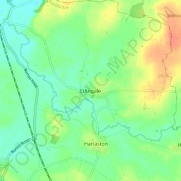
Name: Edingale topographic map, elevation, terrain.

Location: Edingale, Lichfield, Staffordshire, England, B79 9JH, United Kingdom (52.68738 -1.70547 52.72738 -1.66547)

Average elevation: 207 ft

Minimum elevation: 154 ft

Maximum elevation: 295 ft

Other topographic maps

Click on a map to view its topography, its elevation and its terrain.

Hints

United Kingdom > England > Staffordshire > Lichfield

Average elevation: 351 ft

Fisherwick

United Kingdom > England > Staffordshire > Lichfield

Average elevation: 207 ft

Lichfield

United Kingdom > England > Staffordshire > Lichfield

Average elevation: 299 ft

Burntwood

United Kingdom > England > Staffordshire > Lichfield > Chasetown

Average elevation: 482 ft

Beacon Park

United Kingdom > England > Staffordshire > Lichfield

Average elevation: 305 ft

Longdon

United Kingdom > England > Staffordshire > Lichfield

Average elevation: 374 ft

Weeford

United Kingdom > England > Staffordshire > Lichfield

Average elevation: 371 ft

Colton

United Kingdom > England > Staffordshire > Lichfield

Average elevation: 295 ft

Fazeley

United Kingdom > England > Staffordshire > Lichfield

Average elevation: 256 ft

Shenstone

United Kingdom > England > Staffordshire > Lichfield

Average elevation: 410 ft

Wall

United Kingdom > England > Staffordshire > Lichfield

Average elevation: 348 ft

Alrewas

United Kingdom > England > Staffordshire > Lichfield

Average elevation: 194 ft

Harlaston

United Kingdom > England > Staffordshire > Lichfield > Harlaston

Average elevation: 213 ft

King's Bromley

United Kingdom > England > Staffordshire > Lichfield

Average elevation: 217 ft

Gear up for your next adventure:

❄️Traction Cleats - Prevent slips on icy trails during winter hikes
🔭Stargazing Telescopes - Perfect for camping in low-light pollution areas shown on maps
🖼️Topo Map Wall Art - Decorative topographic prints of famous peaks and regions
Backpacking Tents - Weight-optimized shelters for multi-day topographic surveys
🧭Compass with Lanyard - Easy‑carry compass for navigation

As an Amazon Associate, this site earns from qualifying purchases at no extra cost to you.