
Make a donation
Gear up for your next adventure:
As an Amazon Associate, this site earns from qualifying purchases at no extra cost to you.
Ñemby topographic map
Click on the map to display elevation.
Make a donation
Gear up for your next adventure:
As an Amazon Associate, this site earns from qualifying purchases at no extra cost to you.
Ñemby
La ciudad se encuentra en un punto elevado del Departamento Central. Alcanza su mayor elevación en el cerro Ñemby, con tres colinas bastante diferenciadas entre sí divididas por el Arroyo Ñemby y sus afluentes.
Make a donation
Gear up for your next adventure:
As an Amazon Associate, this site earns from qualifying purchases at no extra cost to you.
About this map
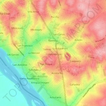
Name: Ñemby topographic map, elevation, terrain.
Location: Ñemby, Departamento de Central, Región Oriental, Paraguay (-25.44370 -57.57204 -25.36098 -57.50616)
Average elevation: 387 ft
Minimum elevation: 157 ft
Maximum elevation: 574 ft
Make a donation
Gear up for your next adventure:
As an Amazon Associate, this site earns from qualifying purchases at no extra cost to you.
Other topographic maps
Click on a map to view its topography, its elevation and its terrain.
Make a donation
Gear up for your next adventure:
As an Amazon Associate, this site earns from qualifying purchases at no extra cost to you.
Make a donation
Gear up for your next adventure:
As an Amazon Associate, this site earns from qualifying purchases at no extra cost to you.
Make a donation
Gear up for your next adventure:
As an Amazon Associate, this site earns from qualifying purchases at no extra cost to you.
Colegio Agustin Fernando de Pinedo
Paraguay > Departamento de Central > San Lorenzo
Average elevation: 397 ft