
Ely topographic map
Click on the map to display elevation.
Ely
Ely is built on a 23-square-mile (60 km2) Kimmeridge Clay island which, at 85 feet (26 m), is the highest land in the Fens. It was due to this topography that Ely was not waterlogged like the surrounding Fenland, and was an island separated from the mainland. Major rivers including the Witham, Welland, Nene and Great Ouse feed into the Fens and, until draining commenced in the eighteenth century, formed freshwater marshes and meres within which peat was laid down. Once the Fens were drained, this peat created a rich and fertile soil ideal for farming.
About this map
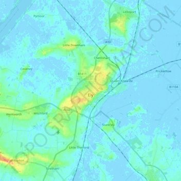
Name: Ely topographic map, elevation, terrain.
Average elevation: 13 ft
Minimum elevation: -16 ft
Maximum elevation: 118 ft
Other topographic maps
Click on a map to view its topography, its elevation and its terrain.
Shepherd's Way
United Kingdom > England > Cambridgeshire > South Cambridgeshire
Average elevation: 52 ft
Icehouse
United Kingdom > England > Cambridgeshire > South Cambridgeshire > Babraham
Average elevation: 118 ft
Long Meadow
United Kingdom > England > Cambridgeshire > East Cambridgeshire > Lode
Average elevation: 23 ft
(no name - just a patch of grass)
United Kingdom > England > Cambridgeshire > South Cambridgeshire > Waterbeach
Average elevation: 20 ft