
Porlock topographic map
Click on the map to display elevation.
About this map
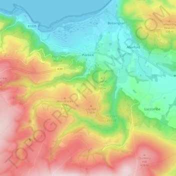
Name: Porlock topographic map, elevation, terrain.
Location: Porlock, Somerset, England, United Kingdom (51.16830 -3.68591 51.22535 -3.58558)
Average elevation: 679 ft
Minimum elevation: 0 ft
Maximum elevation: 1,562 ft
Other topographic maps
Click on a map to view its topography, its elevation and its terrain.
Wales
United Kingdom > England > Somerset > South Somerset > West Camel > Wales
Average elevation: 112 ft
Chard
United Kingdom > England > Somerset
Chard is a town and a civil parish in the English county of Somerset. It lies on the A30 road near the Devon and Dorset borders, 15 miles (24 km) south west of Yeovil. The parish has a population of approximately 13,000 and, at an elevation of 121 metres (397 ft), Chard is the southernmost and one of the…
Average elevation: 443 ft
Small Brook
United Kingdom > England > Somerset > South Somerset > Haselbury Plucknett
Average elevation: 157 ft
Woodhouse
United Kingdom > England > Somerset > South Somerset > Rimpton > Woodhouse
Average elevation: 243 ft
Hill End
United Kingdom > England > Somerset > South Somerset > Hardington Mandeville > Hill End
Average elevation: 203 ft
St. Michael's Tower
United Kingdom > England > Somerset > Mendip District > Glastonbury
Average elevation: 108 ft
Midway
United Kingdom > England > Somerset > Mendip District > Stoke St. Michael > Midway
Average elevation: 715 ft
Friarn
United Kingdom > England > Somerset > Sedgemoor > Nether Stowey > Friarn
Average elevation: 584 ft
Watergore
United Kingdom > England > Somerset > South Somerset > Over Stratton
Average elevation: 138 ft
Kingsbury Regis
United Kingdom > England > Somerset > South Somerset > Milborne Port
Average elevation: 318 ft
Huxham Green
United Kingdom > England > Somerset > Mendip District > East Pennard
Average elevation: 213 ft