
Make a donation
Gear up for your next adventure:
As an Amazon Associate, this site earns from qualifying purchases at no extra cost to you.
Kaunertal topographic map
Click on the map to display elevation.
Make a donation
Gear up for your next adventure:
As an Amazon Associate, this site earns from qualifying purchases at no extra cost to you.
About this map
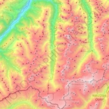
Name: Kaunertal topographic map, elevation, terrain.
Location: Kaunertal, Bezirk Landeck, Tyrol, 6524, Austria (46.82251 10.66156 47.07185 10.82162)
Average elevation: 7,812 ft
Minimum elevation: 2,848 ft
Maximum elevation: 12,208 ft
Make a donation
Gear up for your next adventure:
As an Amazon Associate, this site earns from qualifying purchases at no extra cost to you.
Other topographic maps
Click on a map to view its topography, its elevation and its terrain.
Make a donation
Gear up for your next adventure:
As an Amazon Associate, this site earns from qualifying purchases at no extra cost to you.
Make a donation
Gear up for your next adventure:
As an Amazon Associate, this site earns from qualifying purchases at no extra cost to you.
Pettneu am Arlberg
Austria > Tyrol > Bezirk Landeck > Gemeinde Pettneu am Arlberg > Pettneu am Arlberg
Average elevation: 5,295 ft
Perjen
Austria > Tyrol > Bezirk Landeck > Stadt Landeck > Landeck > Perjen
Average elevation: 3,576 ft