Geolocate

Butlocks Heath topographic map

Click on the map to display elevation.

About this map
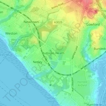
Name: Butlocks Heath topographic map, elevation, terrain.

Location: Butlocks Heath, Eastleigh, Hampshire, England, SO31 5QJ, United Kingdom (50.85938 -1.35938 50.89938 -1.31938)

Average elevation: 66 ft

Minimum elevation: -10 ft

Maximum elevation: 220 ft

Other topographic maps

Click on a map to view its topography, its elevation and its terrain.

Eastleigh

United Kingdom > England > Hampshire > Eastleigh

Average elevation: 108 ft

West End Copse

United Kingdom > England > Hampshire > Eastleigh > West End

Average elevation: 128 ft

Boyatt Wood

United Kingdom > England > Hampshire > Eastleigh > Allbrook

Average elevation: 79 ft

West End

United Kingdom > England > Hampshire > Eastleigh > West End

Average elevation: 102 ft

Bishopstoke

United Kingdom > England > Hampshire > Eastleigh > Bishopstoke

Average elevation: 82 ft

Telegraph Woods

United Kingdom > England > Hampshire > Eastleigh > West End

Average elevation: 164 ft

Hatch Grange

United Kingdom > England > Hampshire > Eastleigh > West End

Average elevation: 128 ft

Allbrook

United Kingdom > England > Hampshire > Eastleigh > Allbrook

Average elevation: 121 ft

Gear up for your next adventure:

🧼Biodegradable Camping Soap - Eco‑friendly soap for outdoor hygiene
🧷Carabiner Set - Durable clips for gear attachment
🗺️Topographic Maps - Detailed topo maps for hiking, exploring and outdoor navigation
🧦Merino Wool Socks - Moisture-wicking, blister-preventing socks for long treks
🪶Fire Starter Kit - Reliable fire starter for survival and camping

As an Amazon Associate, this site earns from qualifying purchases at no extra cost to you.