
Pablo Keys topographic map
Click on the map to display elevation.
About this map
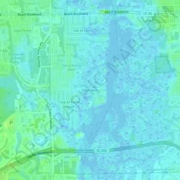
Name: Pablo Keys topographic map, elevation, terrain.
Average elevation: 10 ft
Minimum elevation: -16 ft
Maximum elevation: 33 ft
Duval County trails, hiking, mountain biking, running and outdoor activities
Other topographic maps
Click on a map to view its topography, its elevation and its terrain.
Julington-Durbin Preserve
United States > Florida > Duval County > Jacksonville
Average elevation: 23 ft
L C Ringhaver Park
United States > Florida > Duval County > Jacksonville > Venetia Terrace
Average elevation: 16 ft
Dutton Island Preserve
United States > Florida > Duval County > Jacksonville > Oak Harbor
Average elevation: 7 ft