
Zermatt topographic map
Click on the map to display elevation.
Zermatt
It lies at the upper end of Mattertal at an elevation of 1,620 m (5,310 ft), at the foot of Switzerland's highest peaks. It lies about 10 km (6.2 mi) from the over 3,292 m (10,801 ft) high Theodul Pass bordering Italy. Zermatt is the southernmost commune of the German Sprachraum.
About this map
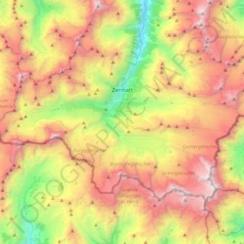
Name: Zermatt topographic map, elevation, terrain.
Location: Zermatt, Visp, Valais/Wallis, 3920, Switzerland (45.91670 7.57538 46.06428 7.90870)
Average elevation: 9,583 ft
Minimum elevation: 4,613 ft
Maximum elevation: 15,154 ft
Other topographic maps
Click on a map to view its topography, its elevation and its terrain.
Castor
Switzerland > Valais/Wallis > Visp > Zermatt
Castor (Italian: Castore) is a mountain in the Pennine Alps on the border between Valais, Switzerland and the Aosta Valley in Italy. It is the higher of a pair of twin peaks (German: Zwillinge), the other being Pollux, named after the Gemini twins of Roman mythology. Castor's peak is at an elevation of 4,225 m…
Average elevation: 12,208 ft
Furi
Switzerland > Valais/Wallis > Visp > Zermatt
Furi is an alpine hamlet in the Pennine Alps, located three kilometers south of Zermatt, Switzerland at an altitude of 1,687m. It is located on a relatively flat area of land between the Gornera and Zmuttbach rivers.
Average elevation: 7,238 ft
Matterhorn
Switzerland > Valais/Wallis > Visp > Zermatt
In 1999, the summit height was precisely determined to be at 4,477.54 m (14,690 ft) above sea level by using Global Positioning System technology as part of the TOWER Project (Top of the World Elevations Remeasurement) and to an accuracy of less than one centimetre, which allows future changes to be tracked.
Average elevation: 10,810 ft