Geolocate

Garryowen topographic map

Click on the map to display elevation.

About this map

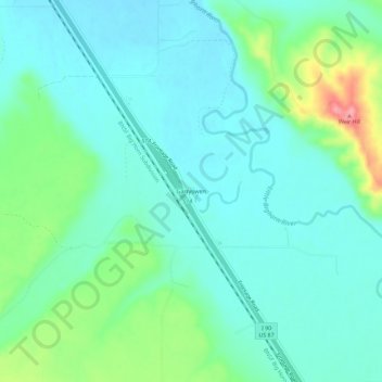
Name: Garryowen topographic map, elevation, terrain.

Location: Garryowen, Big Horn County, Montana, 59031, United States (45.50679 -107.43660 45.54679 -107.39660)

Average elevation: 3,166 ft

Minimum elevation: 3,084 ft

Maximum elevation: 3,435 ft

Big Horn County trails, hiking, mountain biking, running and outdoor activities

Other topographic maps

Click on a map to view its topography, its elevation and its terrain.

Crow Agency

United States > Montana > Big Horn County

Average elevation: 3,150 ft

Lodge Grass

United States > Montana > Big Horn County

Average elevation: 3,406 ft

Hardin

United States > Montana > Big Horn County

Average elevation: 2,907 ft

Crow Agency

United States > Montana > Big Horn County > Crow Agency

Average elevation: 3,150 ft

Busby

United States > Montana > Big Horn County

Average elevation: 3,560 ft

Gear up for your next adventure:

🦟Ultrasonic Repellers - Create a bug-free zone at your camp or rest stop
🔭Compact Binoculars - HD vision for scouting terrain and identifying distant landmarks
🥄Camping Utensil Set - Lightweight utensils for outdoor meals
🩹Survival Bandages - High‑quality bandages for emergencies
🌡️Handheld Weather Meters - Measure wind, temp, and pressure for safe mountain travel

As an Amazon Associate, this site earns from qualifying purchases at no extra cost to you.