Geolocate

Crow Agency topographic map

Click on the map to display elevation.

About this map

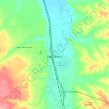
Name: Crow Agency topographic map, elevation, terrain.

Location: Crow Agency, Big Horn County, Montana, 59022, United States (45.56728 -107.49061 45.63899 -107.42663)

Average elevation: 3,150 ft

Minimum elevation: 3,002 ft

Maximum elevation: 3,409 ft

Big Horn County trails, hiking, mountain biking, running and outdoor activities

Other topographic maps

Click on a map to view its topography, its elevation and its terrain.

Garryowen

United States > Montana > Big Horn County

Average elevation: 3,166 ft

Gear up for your next adventure:

🪶Wildlife Field Guides - Learn animal tracking and species ID
🧴Hand Sanitizer - Keep hands clean while hiking
🎒Trekking Poles - Sturdy poles for balance and stability on rough terrain
🛏️Cold Weather Sleeping Bag - Warm sleeping bag for cold conditions
💧Water Filtration Bottles - Safely drink from streams and lakes while exploring

As an Amazon Associate, this site earns from qualifying purchases at no extra cost to you.