Geolocate

Cisco topographic map

Click on the map to display elevation.

About this map

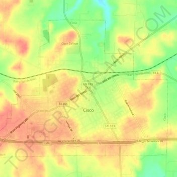
Name: Cisco topographic map, elevation, terrain.

Location: Cisco, Eastland County, Texas, 76437, United States (32.37085 -99.00891 32.40558 -98.95611)

Average elevation: 1,644 ft

Minimum elevation: 1,532 ft

Maximum elevation: 1,709 ft

Eastland County trails, hiking, mountain biking, running and outdoor activities

Other topographic maps

Click on a map to view its topography, its elevation and its terrain.

Union Center

United States > Texas > Eastland County

Average elevation: 1,604 ft

Olden

United States > Texas > Eastland County

Average elevation: 1,549 ft

Ranger

United States > Texas > Eastland County

Average elevation: 1,493 ft

Gear up for your next adventure:

🚑Emergency Bivvies - Heat-reflective sleeping bags for survival situations
🗃️Trail First Aid Kit - Essential kit for outdoor injuries and emergencies
🕶️Glacier Sunglasses - Side shields to protect eyes from high-altitude snow glare
🎒Waterproof Dry Bags - Keep your electronics and maps dry inside your pack
🪶Fire Starter Kit - Reliable fire starter for survival and camping

As an Amazon Associate, this site earns from qualifying purchases at no extra cost to you.