
Make a donation
Gear up for your next adventure:
As an Amazon Associate, this site earns from qualifying purchases at no extra cost to you.
Rottenmann topographic map
Click on the map to display elevation.
Make a donation
Gear up for your next adventure:
As an Amazon Associate, this site earns from qualifying purchases at no extra cost to you.
About this map
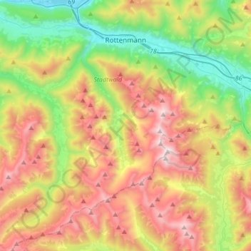
Name: Rottenmann topographic map, elevation, terrain.
Location: Rottenmann, Bezirk Liezen, Stiermarken, 8786, Oostenrijk (47.37018 14.20712 47.55301 14.47523)
Average elevation: 4,557 ft
Minimum elevation: 2,044 ft
Maximum elevation: 7,933 ft
Make a donation
Gear up for your next adventure:
As an Amazon Associate, this site earns from qualifying purchases at no extra cost to you.
Other topographic maps
Click on a map to view its topography, its elevation and its terrain.
Make a donation
Gear up for your next adventure:
As an Amazon Associate, this site earns from qualifying purchases at no extra cost to you.
Schildlehen
Oostenrijk > Stiermarken > Bezirk Liezen > Ramsau am Dachstein
Average elevation: 4,400 ft
Pruggern
Oostenrijk > Stiermarken > Bezirk Liezen > Michaelerberg-Pruggern
Average elevation: 2,894 ft
Make a donation
Gear up for your next adventure:
As an Amazon Associate, this site earns from qualifying purchases at no extra cost to you.
Neuhofen
Oostenrijk > Stiermarken > Bezirk Liezen > Bad Mitterndorf > Neuhofen
Average elevation: 2,766 ft
Oberhausberg
Oostenrijk > Stiermarken > Bezirk Liezen > Haus > Haus im Ennstal > Oberhaus
Average elevation: 3,317 ft
Make a donation
Gear up for your next adventure:
As an Amazon Associate, this site earns from qualifying purchases at no extra cost to you.