
Make a donation
Gear up for your next adventure:
As an Amazon Associate, this site earns from qualifying purchases at no extra cost to you.
Swanwick CP topographic map
Click on the map to display elevation.
Make a donation
Gear up for your next adventure:
As an Amazon Associate, this site earns from qualifying purchases at no extra cost to you.
About this map
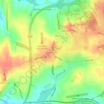
Name: Swanwick CP topographic map, elevation, terrain.
Location: Swanwick CP, Amber Valley, Derbyshire, England, United Kingdom (53.06255 -1.40870 53.08985 -1.37517)
Average elevation: 410 ft
Minimum elevation: 315 ft
Maximum elevation: 495 ft
Make a donation
Gear up for your next adventure:
As an Amazon Associate, this site earns from qualifying purchases at no extra cost to you.
Other topographic maps
Click on a map to view its topography, its elevation and its terrain.
Alfreton Park
United Kingdom > England > Derbyshire > Amber Valley > Alfreton CP > Oakerthorpe
Average elevation: 381 ft
Sawmills
United Kingdom > England > Derbyshire > Amber Valley > Ripley > Fritchley
Average elevation: 390 ft
Make a donation
Gear up for your next adventure:
As an Amazon Associate, this site earns from qualifying purchases at no extra cost to you.