Geolocate

Hiddenite topographic map

Click on the map to display elevation.

Hiddenite

Hiddenite's altitude is 1,160 feet (350 m) above sea level. The community is also a poultry producer.

Wikipedia (CC-BY-SA 3.0)

About this map

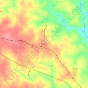
Name: Hiddenite topographic map, elevation, terrain.

Location: Hiddenite, Alexander County, North Carolina, 28636, United States (35.88374 -81.11064 35.92374 -81.07064)

Average elevation: 1,093 ft

Minimum elevation: 909 ft

Maximum elevation: 1,214 ft

Alexander County trails, hiking, mountain biking, running and outdoor activities

Other topographic maps

Click on a map to view its topography, its elevation and its terrain.

Gear up for your next adventure:

🏥Hiking First Aid Kits - Comprehensive medical kits for remote trail injuries
📚USA Hiking Guide Books - Top trail guides and map books
🧤Hiking Gloves - Protective gloves for rugged trails
Backpacking Tent - Lightweight and durable tent for multi‑day hikes
📖Nature Tracking Books - Learn to track wildlife and terrain

As an Amazon Associate, this site earns from qualifying purchases at no extra cost to you.