
Make a donation
Gear up for your next adventure:
As an Amazon Associate, this site earns from qualifying purchases at no extra cost to you.
Thembelihle Local Municipality topographic map
Click on the map to display elevation.
Make a donation
Gear up for your next adventure:
As an Amazon Associate, this site earns from qualifying purchases at no extra cost to you.
About this map
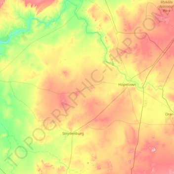
Name: Thembelihle Local Municipality topographic map, elevation, terrain.
Average elevation: 3,671 ft
Minimum elevation: 3,087 ft
Maximum elevation: 4,718 ft
Make a donation
Gear up for your next adventure:
As an Amazon Associate, this site earns from qualifying purchases at no extra cost to you.
Other topographic maps
Click on a map to view its topography, its elevation and its terrain.
Prieska
South Africa > Northern Cape > Pixley ka Seme District Municipality > Siyathemba Local Municipality
Average elevation: 3,166 ft
Three Sisters
South Africa > Northern Cape > Pixley ka Seme District Municipality > Ubuntu Local Municipality
Average elevation: 4,173 ft
Douglas
South Africa > Northern Cape > Pixley ka Seme District Municipality > Siyancuma Local Municipality
Douglas has a record of its elevation above sea level of 1030.22 meters (3379.99 feet). Comparing Douglas district's yearly temperature to South Africa's averages, the records show that it is 4.01% higher with a temperature 25.23 °C (77.41 °F). Douglas is known for its Subtropical desert climate with 38.78…
Average elevation: 3,314 ft
Three Sisters
South Africa > Northern Cape > Pixley ka Seme District Municipality > Ubuntu Local Municipality
Average elevation: 4,173 ft
Make a donation
Gear up for your next adventure:
As an Amazon Associate, this site earns from qualifying purchases at no extra cost to you.
Marydale
South Africa > Northern Cape > Pixley ka Seme District Municipality > Siyathemba Local Municipality
Average elevation: 3,294 ft
Strydenburg
South Africa > Northern Cape > Pixley ka Seme District Municipality > Thembelihle Local Municipality
Average elevation: 3,599 ft
Victoria West
South Africa > Northern Cape > Pixley ka Seme District Municipality > Ubuntu Local Municipality
Victoria West is a town in the central Karoo region of South Africa's Northern Cape province. It is situated on the main N12 route, at an elevation of 1,300 metres (4,300 ft). It is the seat of the Ubuntu Local Municipality within the Pixley ka Seme District Municipality.
Average elevation: 4,232 ft
Douglas
South Africa > Northern Cape > Pixley ka Seme District Municipality > Siyancuma Local Municipality
Douglas has a record of its elevation above sea level of 1030.22 meters (3379.99 feet). Comparing Douglas district's yearly temperature to South Africa's averages, the records show that it is 4.01% higher with a temperature 25.23 °C (77.41 °F). Douglas is known for its Subtropical desert climate with 38.78…
Average elevation: 3,314 ft
Make a donation
Gear up for your next adventure:
As an Amazon Associate, this site earns from qualifying purchases at no extra cost to you.
Vosburg
South Africa > Northern Cape > Pixley ka Seme District Municipality > Kareeberg Local Municipality
Average elevation: 3,730 ft
Orania
South Africa > Northern Cape > Pixley ka Seme District Municipality > Thembelihle Local Municipality
Average elevation: 3,658 ft
Hopetown
South Africa > Northern Cape > Pixley ka Seme District Municipality > Thembelihle Local Municipality
Average elevation: 3,612 ft
Hopetown
South Africa > Northern Cape > Pixley ka Seme District Municipality > Thembelihle Local Municipality
Average elevation: 3,612 ft
Make a donation
Gear up for your next adventure:
As an Amazon Associate, this site earns from qualifying purchases at no extra cost to you.
Orania
South Africa > Northern Cape > Pixley ka Seme District Municipality > Thembelihle Local Municipality
Average elevation: 3,658 ft
Colesberg
South Africa > Northern Cape > Pixley ka Seme District Municipality > Umsobomvu Local Municipality
Average elevation: 4,567 ft
Victoria West
South Africa > Northern Cape > Pixley ka Seme District Municipality > Ubuntu Local Municipality
Victoria West is a town in the central Karoo region of South Africa's Northern Cape province. It is situated on the main N12 route, at an elevation of 1,300 metres (4,300 ft). It is the seat of the Ubuntu Local Municipality within the Pixley ka Seme District Municipality.
Average elevation: 4,232 ft
Carnarvon
South Africa > Northern Cape > Pixley ka Seme District Municipality > Kareeberg Local Municipality
Average elevation: 4,173 ft
Make a donation
Gear up for your next adventure:
As an Amazon Associate, this site earns from qualifying purchases at no extra cost to you.
Prieska
South Africa > Northern Cape > Pixley ka Seme District Municipality > Siyathemba Local Municipality
Average elevation: 3,166 ft
Britstown
South Africa > Northern Cape > Pixley ka Seme District Municipality > Emthanjeni Local Municipality
Average elevation: 3,707 ft
Twyfelberg
South Africa > Northern Cape > Pixley ka Seme District Municipality > Umsobomvu Local Municipality
Average elevation: 4,560 ft
Richmond
South Africa > Northern Cape > Pixley ka Seme District Municipality > Ubuntu Local Municipality
Average elevation: 4,767 ft
Make a donation
Gear up for your next adventure:
As an Amazon Associate, this site earns from qualifying purchases at no extra cost to you.
De Aar
South Africa > Northern Cape > Pixley ka Seme District Municipality > Emthanjeni Local Municipality
Average elevation: 4,124 ft
Orania
South Africa > Northern Cape > Pixley ka Seme District Municipality > Thembelihle Local Municipality
Average elevation: 3,658 ft
De Aar
South Africa > Northern Cape > Pixley ka Seme District Municipality > Emthanjeni Local Municipality
Average elevation: 4,124 ft
Vosburg
South Africa > Northern Cape > Pixley ka Seme District Municipality > Kareeberg Local Municipality
Average elevation: 3,730 ft
Make a donation
Gear up for your next adventure:
As an Amazon Associate, this site earns from qualifying purchases at no extra cost to you.
Prieska
South Africa > Northern Cape > Pixley ka Seme District Municipality > Siyathemba Local Municipality
Average elevation: 3,166 ft
Strydenburg
South Africa > Northern Cape > Pixley ka Seme District Municipality > Thembelihle Local Municipality
Average elevation: 3,599 ft
Noupoort
South Africa > Northern Cape > Pixley ka Seme District Municipality > Umsobomvu Local Municipality
Average elevation: 5,056 ft
Vanderkloof
South Africa > Northern Cape > Pixley ka Seme District Municipality > Renosterberg Local Municipality
Average elevation: 3,999 ft
Make a donation
Gear up for your next adventure:
As an Amazon Associate, this site earns from qualifying purchases at no extra cost to you.
Hopetown
South Africa > Northern Cape > Pixley ka Seme District Municipality > Thembelihle Local Municipality
Average elevation: 3,612 ft
Hopetown
South Africa > Northern Cape > Pixley ka Seme District Municipality > Thembelihle Local Municipality
Average elevation: 3,612 ft
Marydale
South Africa > Northern Cape > Pixley ka Seme District Municipality > Siyathemba Local Municipality > Marydale
Average elevation: 3,294 ft