Geolocate

Gordon topographic map

Click on the map to display elevation.

About this map

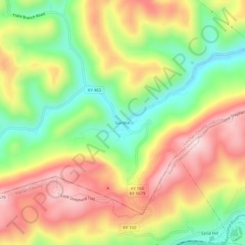
Name: Gordon topographic map, elevation, terrain.

Location: Gordon, Letcher County, Kentucky, 40823, United States (36.97287 -83.04433 37.01287 -83.00433)

Average elevation: 1,926 ft

Minimum elevation: 1,234 ft

Maximum elevation: 2,635 ft

Letcher County trails, hiking, mountain biking, running and outdoor activities

Other topographic maps

Click on a map to view its topography, its elevation and its terrain.

Fleming-Neon

United States > Kentucky > Letcher County

Average elevation: 1,604 ft

Jenkins

United States > Kentucky > Letcher County

Average elevation: 1,936 ft

McRoberts

United States > Kentucky > Letcher County

Average elevation: 1,877 ft

Gear up for your next adventure:

📶Satellite Messenger - Communication device off‑grid
🧯Emergency Survival Kit - All‑in‑one survival essentials for the backcountry
📱Solar Portable Charger - Solar power bank for charging devices off‑grid
🎒Trail Energy Bars - High‑calorie bars for hiking energy
🪑Portable Camp Table - Compact table for campsite meals

As an Amazon Associate, this site earns from qualifying purchases at no extra cost to you.