
Make a donation
Gear up for your next adventure:
As an Amazon Associate, this site earns from qualifying purchases at no extra cost to you.
Kouts topographic map
Click on the map to display elevation.
Make a donation
Gear up for your next adventure:
As an Amazon Associate, this site earns from qualifying purchases at no extra cost to you.
About this map
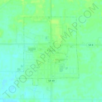
Name: Kouts topographic map, elevation, terrain.
Location: Kouts, Porter County, Indiana, 46347, United States (41.30745 -87.03836 41.32558 -87.01603)
Average elevation: 682 ft
Minimum elevation: 659 ft
Maximum elevation: 705 ft
Porter County trails, hiking, mountain biking, running and outdoor activities
Make a donation
Gear up for your next adventure:
As an Amazon Associate, this site earns from qualifying purchases at no extra cost to you.
Other topographic maps
Click on a map to view its topography, its elevation and its terrain.
Beverly Shores
United States > Indiana > Porter County > Beverly Shores > Beverly Shores
Average elevation: 597 ft