
Alpine topographic map
Click on the map to display elevation.
About this map
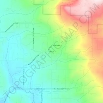
Name: Alpine topographic map, elevation, terrain.
Location: Alpine, Clark County, Washington, United States (45.76817 -122.44426 45.80817 -122.40426)
Average elevation: 912 ft
Minimum elevation: 331 ft
Maximum elevation: 2,041 ft
Clark County trails, hiking, mountain biking, running and outdoor activities
Other topographic maps
Click on a map to view its topography, its elevation and its terrain.
Waterfront Park
United States > Washington > Clark County > Vancouver
A 12-foot (3.7 m) stone and bronze structure called Headwaters (or sometimes the Headwaters Wall) designed by artist Larry Kirkland was installed at Waterfront Park in August 2019. It is an interactive water feature that cost $3.5 million to construct. Headwaters features a cast bronze bas relief map of the…
Average elevation: 43 ft
Sandy Swimming Hole Park
United States > Washington > Clark County > Washougal
Average elevation: 213 ft