Make a donation
Gear up for your next adventure:
As an Amazon Associate, this site earns from qualifying purchases at no extra cost to you.
Pattiswick topographic map
Click on the map to display elevation.
Make a donation
Gear up for your next adventure:
As an Amazon Associate, this site earns from qualifying purchases at no extra cost to you.
About this map
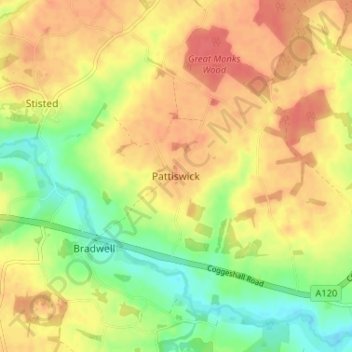
Name: Pattiswick topographic map, elevation, terrain.
Location: Pattiswick, Braintree, Essex, England, CM77 8BQ, United Kingdom (51.86440 0.61838 51.90440 0.65838)
Average elevation: 187 ft
Minimum elevation: 92 ft
Maximum elevation: 256 ft
Make a donation
Gear up for your next adventure:
As an Amazon Associate, this site earns from qualifying purchases at no extra cost to you.
Other topographic maps
Click on a map to view its topography, its elevation and its terrain.
Make a donation
Gear up for your next adventure:
As an Amazon Associate, this site earns from qualifying purchases at no extra cost to you.
Helions Bumpstead
United Kingdom > England > Essex > Braintree > Helions Bumpstead
Average elevation: 335 ft
Make a donation
Gear up for your next adventure:
As an Amazon Associate, this site earns from qualifying purchases at no extra cost to you.
Great Maplestead
United Kingdom > England > Essex > Braintree > Great Maplestead
Average elevation: 217 ft
Hedingham Castle
United Kingdom > England > Essex > Braintree > Castle Hedingham
Average elevation: 220 ft
Make a donation
Gear up for your next adventure:
As an Amazon Associate, this site earns from qualifying purchases at no extra cost to you.
Tilbury Juxta Clare
United Kingdom > England > Essex > Braintree > Tilbury juxta Clare
Average elevation: 253 ft
Make a donation
Gear up for your next adventure:
As an Amazon Associate, this site earns from qualifying purchases at no extra cost to you.
Make a donation
Gear up for your next adventure:
As an Amazon Associate, this site earns from qualifying purchases at no extra cost to you.
