
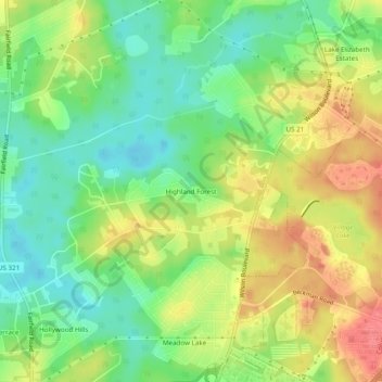
Highland Forest topographic map
Interactive map
Click on the map to display elevation.
About this map
Name: Highland Forest topographic map, elevation, terrain.
Average elevation: 285 ft
Minimum elevation: 187 ft
Maximum elevation: 400 ft
Other topographic maps
Click on a map to view its topography, its elevation and its terrain.
Columbia
United States > South Carolina > Richland County
Columbia, Richland County, South Carolina, United States
Average elevation: 292 ft
Forest Hills
United States > South Carolina > Richland County > Columbia
Forest Hills, Columbia, Richland County, South Carolina, 29204, United States
Average elevation: 282 ft
Blythewood
United States > South Carolina > Richland County > Blythewood
Blythewood, Richland County, South Carolina, 29016, United States
Average elevation: 479 ft
Elmwood Park Historic District
United States > South Carolina > Richland County > Columbia
Elmwood Park Historic District, Columbia, Richland County, South Carolina, 29202, United States
Average elevation: 249 ft
Riverbanks
United States > South Carolina > Richland County > Columbia
Riverbanks, Columbia, Richland County, South Carolina, 29202, United States
Average elevation: 226 ft
Hopkins
United States > South Carolina > Richland County
Hopkins, Richland County, South Carolina, 29061, United States
Average elevation: 164 ft
Gadsden
United States > South Carolina > Richland County
Gadsden, Richland County, South Carolina, 29052, United States
Average elevation: 144 ft
Langfords Crossroads
United States > South Carolina > Richland County
Langfords Crossroads, Richland County, South Carolina, United States
Average elevation: 371 ft
Congaree
United States > South Carolina > Richland County
Congaree, Richland County, South Carolina, United States
Average elevation: 210 ft
Strathaven Forest
United States > South Carolina > Richland County > Columbia
Strathaven Forest, Columbia, Richland County, South Carolina, 29209, United States
Average elevation: 269 ft
Haskell Heights
United States > South Carolina > Richland County
Haskell Heights, Richland County, South Carolina, 29203, United States
Average elevation: 272 ft
Fairfield Arms
United States > South Carolina > Richland County > Columbia
Fairfield Arms, Columbia, Richland County, South Carolina, 29203, United States
Average elevation: 285 ft
Saint Andrews
United States > South Carolina > Richland County
Saint Andrews, Richland County, South Carolina, 29210, United States
Average elevation: 253 ft
Harbison State Forest
United States > South Carolina > Richland County > Columbia
Harbison State Forest, Columbia, Richland County, South Carolina, United States
Average elevation: 259 ft
Sesquicentennial State Park
United States > South Carolina > Richland County
Sesquicentennial State Park, Richland County, South Carolina, United States
Average elevation: 318 ft
Independents
United States > South Carolina > Richland County
Independents, Richland County, South Carolina, 29209, United States
Average elevation: 223 ft
Forest Acres
United States > South Carolina > Richland County
Forest Acres, Richland County, South Carolina, United States
Average elevation: 279 ft
Stevensons Lake
United States > South Carolina > Richland County
Stevensons Lake, Richland County, South Carolina, United States
Average elevation: 328 ft
Blythewood
United States > South Carolina > Richland County
Blythewood, Richland County, South Carolina, United States
Average elevation: 449 ft
Weddell
United States > South Carolina > Richland County > Weddell
Weddell, Richland County, South Carolina, 29223, United States
Average elevation: 289 ft