
Make a donation
Gear up for your next adventure:
As an Amazon Associate, this site earns from qualifying purchases at no extra cost to you.
Forest Acres topographic map
Click on the map to display elevation.
Make a donation
Gear up for your next adventure:
As an Amazon Associate, this site earns from qualifying purchases at no extra cost to you.
About this map
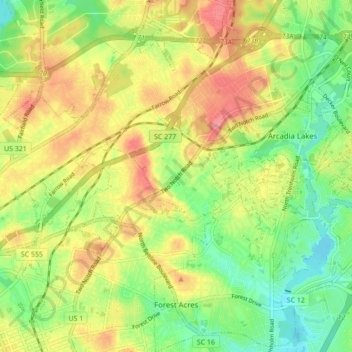
Name: Forest Acres topographic map, elevation, terrain.
Average elevation: 279 ft
Minimum elevation: 154 ft
Maximum elevation: 413 ft
Richland County trails, hiking, mountain biking, running and outdoor activities
Make a donation
Gear up for your next adventure:
As an Amazon Associate, this site earns from qualifying purchases at no extra cost to you.
Other topographic maps
Click on a map to view its topography, its elevation and its terrain.
Harbison State Forest
United States > South Carolina > Richland County > Columbia
Average elevation: 259 ft
Forest I At Harbison
United States > South Carolina > Richland County > Columbia
Average elevation: 285 ft
Make a donation
Gear up for your next adventure:
As an Amazon Associate, this site earns from qualifying purchases at no extra cost to you.
Sesquicentennial State Park
United States > South Carolina > Richland County
This park offers three picnic shelters, four picnic pads, and 84 campsites that vary in amenities & sizes. The park provides rental fishing boats, paddle boats, standup paddleboards, kayaks, canoes, fishing access to the 30-acre (12 ha) park lake, and four trails providing over 12 miles (19 km) of recreational…
Average elevation: 318 ft
Make a donation
Gear up for your next adventure:
As an Amazon Associate, this site earns from qualifying purchases at no extra cost to you.
Forest I At Harbison
United States > South Carolina > Richland County > Columbia
Average elevation: 285 ft
Make a donation
Gear up for your next adventure:
As an Amazon Associate, this site earns from qualifying purchases at no extra cost to you.
Riverbanks
United States > South Carolina > Richland County > Columbia > Riverbanks
Average elevation: 226 ft
Lincolnshire
United States > South Carolina > Richland County > Lincolnshire
Average elevation: 262 ft
Make a donation
Gear up for your next adventure:
As an Amazon Associate, this site earns from qualifying purchases at no extra cost to you.