
Make a donation
Gear up for your next adventure:
As an Amazon Associate, this site earns from qualifying purchases at no extra cost to you.
Safi topographic map
Click on the map to display elevation.
Make a donation
Gear up for your next adventure:
As an Amazon Associate, this site earns from qualifying purchases at no extra cost to you.
About this map
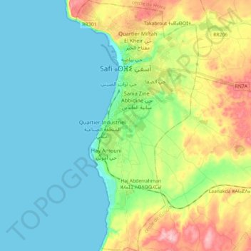
Name: Safi topographic map, elevation, terrain.
Location: Safi, Safi Province, Marrakech-Safi, Morocco (32.18978 -9.27460 32.34006 -9.18788)
Average elevation: 154 ft
Minimum elevation: 0 ft
Maximum elevation: 538 ft
Make a donation
Gear up for your next adventure:
As an Amazon Associate, this site earns from qualifying purchases at no extra cost to you.
Other topographic maps
Click on a map to view its topography, its elevation and its terrain.
Toubkal
Morocco > Marrakech-Safi > Cercle d'Asni > Asni
Toubkal, also Jbel Toubkal or Jebel Toubkal, is a mountain in southwestern Morocco, located in the Toubkal National Park. At 4,167 m (13,671 ft), it is the highest peak in Morocco, the Atlas Mountains, North Africa and the Arab world. Located 63 km (39 mi) south of the city of Marrakesh, and visible from it,…
Average elevation: 11,864 ft
Make a donation
Gear up for your next adventure:
As an Amazon Associate, this site earns from qualifying purchases at no extra cost to you.
Oukaïmeden
Morocco > Marrakech-Safi > Cercle de Tahannaout دائرة تحناوت > Oukaimeden
The skiing area is at an altitude of between 2,600 metres (8,500 ft) and 3,200 metres (10,500 ft) and has six ski lifts. There are some hotels and ski rental facilities nearby. Recently oukaimeden is more known of it’s Bouldering potential then the skiing possibilities.
Average elevation: 7,946 ft
Tanammert
Morocco > Marrakech-Safi > cercle d'Imintanout > Lalla Aaziza > Igrnsouk
Average elevation: 3,635 ft
Make a donation
Gear up for your next adventure:
As an Amazon Associate, this site earns from qualifying purchases at no extra cost to you.
Tizert
Morocco > Marrakech-Safi > Cercle de Tahannaout دائرة تحناوت > Sti Fadma
Average elevation: 4,770 ft
RP2030
Morocco > Marrakech-Safi > Cercle d'Asni > Asni > Tamatert > Azib Amguedoul
Average elevation: 7,142 ft
Make a donation
Gear up for your next adventure:
As an Amazon Associate, this site earns from qualifying purchases at no extra cost to you.