
Red Lion topographic map
Click on the map to display elevation.
About this map
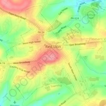
Name: Red Lion topographic map, elevation, terrain.
Location: Red Lion, York County, Pennsylvania, 17356, United States (39.88724 -76.62255 39.91130 -76.59148)
Average elevation: 860 ft
Minimum elevation: 696 ft
Maximum elevation: 1,014 ft
York County trails, hiking, mountain biking, running and outdoor activities
Other topographic maps
Click on a map to view its topography, its elevation and its terrain.
Rosemount
United States > Pennsylvania > York County > Spring Garden Township
Average elevation: 548 ft
Hanover Junction
United States > Pennsylvania > York County > North Codorus Township
Average elevation: 614 ft
Strickhousers
United States > Pennsylvania > York County > North Codorus Township
Average elevation: 673 ft
Bass Lake
United States > Pennsylvania > York County > Newberry Township > Valley Green
Average elevation: 469 ft
Starview
United States > Pennsylvania > York County > East Manchester Township
Average elevation: 509 ft
Pleasureville
United States > Pennsylvania > York County > Springettsbury Township
Average elevation: 476 ft
East York
United States > Pennsylvania > York County > Springettsbury Township
Average elevation: 469 ft
Stoverstown
United States > Pennsylvania > York County > North Codorus Township
Average elevation: 561 ft
Rosemount
United States > Pennsylvania > York County > Spring Garden Township
Average elevation: 548 ft
Reesers Summit
United States > Pennsylvania > York County > Fairview Township
Average elevation: 545 ft
Spring Plains
United States > Pennsylvania > York County > Springettsbury Township
Average elevation: 495 ft
Spring Plains
United States > Pennsylvania > York County > Springettsbury Township
Average elevation: 495 ft
Delta Ridge
United States > Pennsylvania > York County > Peach Bottom Township
Average elevation: 492 ft
Airville
United States > Pennsylvania > York County > Lower Chanceford Township
Average elevation: 686 ft