
Adigrat topographic map
Click on the map to display elevation.
Adigrat
Adigrat (Tigrinya: ዓዲግራት, ʿaddigrat, also called ʿAddi Grat) is a city and separate woreda in Tigray Region of Ethiopia. It is located in the Misraqawi Zone at longitude and latitude 14°16′N 39°27′E / 14.267°N 39.450°E / 14.267; 39.450Coordinates: 14°16′N 39°27′E / 14.267°N 39.450°E / 14.267; 39.450, with an elevation of 2,457 metres (8,061 ft) above sea level and below a high ridge to the west. Adigrat is a strategically important gateway to Eritrea and the Red Sea. Adigrat was part of Ganta Afeshum woreda before a separate woreda was created for the city. Currently, Adigrat serves as the capital of the Eastern Tigray zone.
About this map
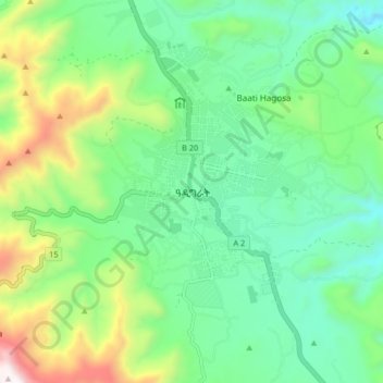
Name: Adigrat topographic map, elevation, terrain.
Location: Adigrat, Eastern Tigray, Tigray, Ethiopia (14.23741 39.42150 14.31741 39.50150)
Average elevation: 8,389 ft
Minimum elevation: 7,385 ft
Maximum elevation: 10,823 ft
Other topographic maps
Click on a map to view its topography, its elevation and its terrain.
Mek'elē
Mekelle (Tigrinya: መቐለ), or Mekele, is a special zone and capital of the Tigray Region of Ethiopia. Mekelle was formerly the capital of Enderta awraja in Tigray. It is located around 780 kilometres (480 mi) north of the Ethiopian capital Addis Ababa, with an elevation of 2,254 metres (7,395 ft) above sea…
Average elevation: 6,857 ft
Alamata
Alamata (Tigrinya: ኣላማጣ ) is a town in the Tigray Region of Ethiopia. Located in the Debubawi (Southern) zone of Tigray it has a latitude and longitude of 12°25′N 39°33′E / 12.417°N 39.550°E / 12.417; 39.550 and an elevation of 1,520 metres (4,990 ft) above sea level and is located…
Average elevation: 5,164 ft
Mek'elē
Mekelle (Tigrinya: መቐለ), or Mekele, is a special zone and capital of the Tigray Region of Ethiopia. Mekelle was formerly the capital of Enderta awraja in Tigray. It is located around 780 kilometres (480 mi) north of the Ethiopian capital Addis Ababa, with an elevation of 2,254 metres (7,395 ft) above sea…
Average elevation: 6,857 ft
Mek'elē
Mekelle (Tigrinya: መቐለ), or Mek'ele, is a special zone and capital of the Tigray Region of Ethiopia. Mekelle was formerly the capital of Enderta awraja in Tigray. It is located around 780 kilometres (480 mi) north of the Ethiopian capital Addis Ababa, with an elevation of 2,254 metres (7,395 ft) above…
Average elevation: 6,857 ft