
Make a donation
Gear up for your next adventure:
As an Amazon Associate, this site earns from qualifying purchases at no extra cost to you.
Urubamba topographic map
Click on the map to display elevation.
Make a donation
Gear up for your next adventure:
As an Amazon Associate, this site earns from qualifying purchases at no extra cost to you.
About this map
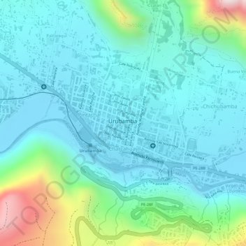
Name: Urubamba topographic map, elevation, terrain.
Location: Urubamba, Province of Urubamba, Cusco, 08661, Peru (-13.31333 -72.12369 -13.29901 -72.10317)
Average elevation: 9,744 ft
Minimum elevation: 9,344 ft
Maximum elevation: 11,188 ft
Make a donation
Gear up for your next adventure:
As an Amazon Associate, this site earns from qualifying purchases at no extra cost to you.
Other topographic maps
Click on a map to view its topography, its elevation and its terrain.
Cuzco
Cusco is the seventh-most populous city in Peru; in 2017, it had a population of 428,450. It is also the largest city in the Peruvian Andes and the region is the seventh-most populous metropolitan area of Peru. Its elevation is around 3,400 m (11,200 ft). The largest district in the city is the Cusco District,…
Average elevation: 12,434 ft
Vinicunca
Vinicunca, or Winikunka, also called Montaña de Siete Colores (literally: Mountain of seven colors), Montaña de Colores (Mountain of colors) or Montaña Arcoíris (Rainbow Mountain), is a mountain in the Andes of Peru with an altitude of 5,200 metres (17,100 ft) above sea level. It is located on the road to…
Average elevation: 15,991 ft
Sacred Valley of the Incas
The valley, running generally west to east, is understood to include everything along the Urubamba River between the town and Inca ruins at Písac and Machu Picchu, 100 kilometres (62 mi) distant. The Sacred Valley has elevations above sea level along the river ranging from 3,000 metres (9,800 ft) at Pisac to…
Average elevation: 12,493 ft
Make a donation
Gear up for your next adventure:
As an Amazon Associate, this site earns from qualifying purchases at no extra cost to you.
Chinchaypujio
The district of Chinchaypujio has a 2,000-metre (6,600 ft) altitude spread from south to north; hence, the district is home to multiple climate zones. In the south, the Apurímac River runs at 2,200-metre (7,200 ft) elevation where Banana Isla Maleño and other tropical fruit can be grown, in the north, the…
Average elevation: 11,824 ft
Make a donation
Gear up for your next adventure:
As an Amazon Associate, this site earns from qualifying purchases at no extra cost to you.
Vinicunca
Vinicunca, or Winikunka, also called Montaña de Siete Colores (literally: Mountain of seven colors), Montaña de Colores (Mountain of colors) or Montaña Arcoíris (Rainbow Mountain), is a mountain in the Andes of Peru with an altitude of 5,200 metres (17,100 ft) above sea level. It is located on the road to…
Average elevation: 15,991 ft
Make a donation
Gear up for your next adventure:
As an Amazon Associate, this site earns from qualifying purchases at no extra cost to you.
Make a donation
Gear up for your next adventure:
As an Amazon Associate, this site earns from qualifying purchases at no extra cost to you.
Make a donation
Gear up for your next adventure:
As an Amazon Associate, this site earns from qualifying purchases at no extra cost to you.
Cuzco
Cusco is the seventh-most populous city in Peru; in 2017, it had a population of 428,450. It is also the largest city in the Peruvian Andes and the region is the seventh-most populous metropolitan area of Peru. Its elevation is around 3,400 m (11,200 ft). The largest district in the city is the Cusco District,…
Average elevation: 12,434 ft
Make a donation
Gear up for your next adventure:
As an Amazon Associate, this site earns from qualifying purchases at no extra cost to you.
City of Cuzco
Cusco, often spelled Cuzco[a] ([ˈkusko]; Quechua: Qusqu ([ˈqɔsqɔ])), is a city in Southeastern Peru near the Urubamba Valley of the Andes mountain range. It is the capital of the Cusco Region and of the Cusco Province. The city is the seventh most populous in Peru; in 2017, it had a population of 428,450.…
Average elevation: 11,329 ft
Make a donation
Gear up for your next adventure:
As an Amazon Associate, this site earns from qualifying purchases at no extra cost to you.
Cuzco
Cusco is the seventh-most populous city in Peru; in 2017, it had a population of 428,450. It is also the largest city in the Peruvian Andes and the region is the seventh-most populous metropolitan area of Peru. Its elevation is around 3,400 m (11,200 ft). The largest district in the city is the Cusco District,…
Average elevation: 12,434 ft
Nevado Salkantay
Salcantay, Salkantay or Sallqantay (in Quechua) is the highest peak in the Vilcabamba mountain range, part of the Peruvian Andes. It is located in the Cusco Region, about 60 km (40 mi) west-northwest of the city of Cusco. It is the 38th-highest peak in the Andes and the twelfth-highest in Peru. However, as a…
Average elevation: 17,277 ft
Make a donation
Gear up for your next adventure:
As an Amazon Associate, this site earns from qualifying purchases at no extra cost to you.
Make a donation
Gear up for your next adventure:
As an Amazon Associate, this site earns from qualifying purchases at no extra cost to you.
Vilcabamba
Vilcabamba District is one of fourteen districts of the La Convención Province in the Cusco Region in Peru. The capital of the province is the Centro Poblado Lucma, which has an elevation of 2,943 metres (9,656 ft). Vitcos was an important city of the Neo-Inca State (1537-1572). Its ruins are now preserved as…
Average elevation: 9,088 ft
Make a donation
Gear up for your next adventure:
As an Amazon Associate, this site earns from qualifying purchases at no extra cost to you.
Cuzco
Cusco is the seventh-most populous city in Peru; in 2017, it had a population of 428,450. It is also the largest city in the Peruvian Andes and the region is the seventh-most populous metropolitan area of Peru. Its elevation is around 3,400 m (11,200 ft). The largest district in the city is the Cusco District,…
Average elevation: 12,434 ft
Make a donation
Gear up for your next adventure:
As an Amazon Associate, this site earns from qualifying purchases at no extra cost to you.
Make a donation
Gear up for your next adventure:
As an Amazon Associate, this site earns from qualifying purchases at no extra cost to you.
Make a donation
Gear up for your next adventure:
As an Amazon Associate, this site earns from qualifying purchases at no extra cost to you.
Make a donation
Gear up for your next adventure:
As an Amazon Associate, this site earns from qualifying purchases at no extra cost to you.
Vinicunca
Vinicunca, or Winikunka, also called Montaña de Siete Colores (literally: Mountain of seven colors), Montaña de Colores (Mountain of colors) or Montaña Arcoíris (Rainbow Mountain), is a mountain in the Andes of Peru with an altitude of 5,036 metres (16,522 ft) above sea level. It is located on the road to…
Average elevation: 15,991 ft
Make a donation
Gear up for your next adventure:
As an Amazon Associate, this site earns from qualifying purchases at no extra cost to you.
Make a donation
Gear up for your next adventure:
As an Amazon Associate, this site earns from qualifying purchases at no extra cost to you.
Make a donation
Gear up for your next adventure:
As an Amazon Associate, this site earns from qualifying purchases at no extra cost to you.
Make a donation
Gear up for your next adventure:
As an Amazon Associate, this site earns from qualifying purchases at no extra cost to you.
Make a donation
Gear up for your next adventure:
As an Amazon Associate, this site earns from qualifying purchases at no extra cost to you.
Cuzco
Cusco or Cuzco (Latin American Spanish: [ˈkusko]; Quechua: Qosqo or Qusqu, both pronounced [ˈqosqɔ]) is a city in southeastern Peru, near the Sacred Valley of the Andes mountain range and the Huatanay river. It is the capital of the eponymous province and department. The city is the seventh most populous in…
Average elevation: 12,434 ft
Make a donation
Gear up for your next adventure:
As an Amazon Associate, this site earns from qualifying purchases at no extra cost to you.
Make a donation
Gear up for your next adventure:
As an Amazon Associate, this site earns from qualifying purchases at no extra cost to you.
City of Cuzco
Cusco, often spelled Cuzco ([ˈkusko]; Quechua: Qusqu ([ˈqɔsqɔ])), is a city in Southeastern Peru near the Urubamba Valley of the Andes mountain range. It is the capital of the Cusco Region and of the Cusco Province. The city is the seventh most populous in Peru; in 2017, it had a population of 428,450. Its…
Average elevation: 11,329 ft
Make a donation
Gear up for your next adventure:
As an Amazon Associate, this site earns from qualifying purchases at no extra cost to you.
Province of Paruro
The provincial capital of Paruro, with population of 3,855, lies at 3,057 meters (10,032 ft) altitude. Two and a half hours by bus from Cusco, in the bottom of a deep valley, it is bordered on one side by the Rio Paruro, a feeder of the Apurímac River. A number of small Inca and pre-Inca ruins are in the…
Average elevation: 12,530 ft
Make a donation
Gear up for your next adventure:
As an Amazon Associate, this site earns from qualifying purchases at no extra cost to you.
Make a donation
Gear up for your next adventure:
As an Amazon Associate, this site earns from qualifying purchases at no extra cost to you.
Pisaq National Archaeological Park
The town is located in the district of Pisac, province of Calca at the southern end of the Sacred Valley at an altitude of 2,972 metres (9,751 ft), 32 kilometres (20 mi) northeast of Cusco. The town straddles the Vilcanota River with most of the settlement on its right bank, where it is laid out in a grid…
Average elevation: 12,625 ft
Make a donation
Gear up for your next adventure:
As an Amazon Associate, this site earns from qualifying purchases at no extra cost to you.