Geolocate

The Hamptons topographic map

Click on the map to display elevation.

About this map

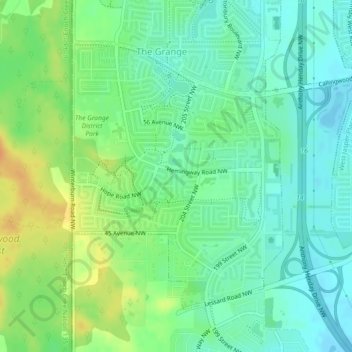
Name: The Hamptons topographic map, elevation, terrain.

Location: The Hamptons, The Grange, Edmonton, Alberta, Canada (53.47722 -113.68908 53.49775 -113.66188)

Average elevation: 2,297 ft

Minimum elevation: 2,254 ft

Maximum elevation: 2,365 ft

Other topographic maps

Click on a map to view its topography, its elevation and its terrain.

William Hawrelak Park

Canada > Alberta > Edmonton

Average elevation: 2,129 ft

Horseshoe Lake

Canada > Alberta > Edmonton

Average elevation: 2,231 ft

landslide

Canada > Alberta > Edmonton

Average elevation: 2,192 ft

Ormsby Park

Canada > Alberta > Edmonton

Average elevation: 2,257 ft

Gear up for your next adventure:

🔪Outdoor Multitools - Essential survival tools for gear repair and field use
🪶Compact Camp Shovel - Folding shovel for campsite tasks
🗻Climbing Gear Basics - Essential gear for beginner climbers
📶Vehicle Signal Boosters - Improve reception in rural areas while driving to trailheads
🎒Gear Packing Cubes - Organize your backpack efficiently

As an Amazon Associate, this site earns from qualifying purchases at no extra cost to you.